Drygalski Fjord facts for kids
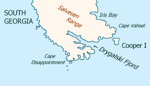
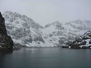
Drygalski Fjord is a long, narrow bay on the southeast coast of South Georgia. It is about 1 mile (1.6 km) wide and stretches 7 miles (11 km) inland. This fjord is located just north of a place called Nattriss Head.
Explorers from the Second German Antarctic Expedition discovered and mapped this fjord in 1911–12. The expedition was led by Wilhelm Filchner. They named the fjord after Professor Erich von Drygalski. He was the leader of the First German Antarctica Expedition from 1901–03.
Some historians believe that Drygalski Fjord might be where an explorer named Anthony de la Roché stayed for two weeks in April 1675.
Contents
Exploring Drygalski Fjord's Features
This section will tell you about some important places around Drygalski Fjord.
Nattriss Head: A Rocky Landmark
Nattriss Head is a small but easy-to-spot rocky point. It marks the southern entrance to Drygalski Fjord. Like the fjord itself, Filchner's expedition mapped Nattriss Head.
It was first named Nattriss Point after E.A. Nattriss. He was a shipping officer for the Discovery Committee. This name was given after surveys by the Discovery Investigations team in 1927. Later, its name was changed to Nattriss Head. This was done to avoid confusion with another place called Nattriss Point on Saunders Island in the South Sandwich Islands.
Brandt Cove: A Hidden Bay
Brandt Cove is a small bay located on the south side of Drygalski Fjord. It is about 1 nautical mile (1.9 km) north of the end of Larsen Harbour.
The South Georgia Survey explored and mapped Brandt Cove between 1951 and 1957. The UK Antarctic Place-Names Committee named it after an American economist named Karl Brandt. South of Brandt Cove, you'll find Mount Mair. This mountain separates Brandt Cove from Larsen Harbour.
See also
 In Spanish: Fiordo de Drygalski para niños
 | Jewel Prestage |
 | Ella Baker |
 | Fannie Lou Hamer |


