Larsen Harbour facts for kids
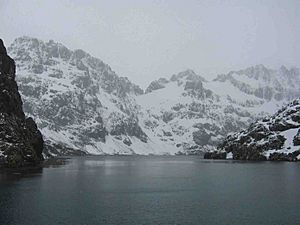
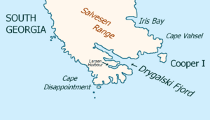
Larsen Harbour (Spanish: Bahía Larsen) is a narrow inlet, about 2.6 miles (4.2 km) long. It is made of volcanic rocks. This harbour is a branch of Drygalski Fjord, found at the southeast end of South Georgia Island.
It was first mapped by the Second German Antarctic Expedition in 1911–12. The expedition was led by Wilhelm Filchner. He named the harbour after Captain Carl Anton Larsen. Larsen was a Norwegian explorer who helped a lot with exploring Antarctica. He was the first to find fossils on the continent. For this discovery, he received a special award called the Back Grant from the Royal Geographical Society. Larsen also started the Antarctic whaling industry. He founded the whaling station of Grytviken on South Georgia.
The mountains around Larsen Harbour are almost completely surrounded by land. Sir Ernest Shackleton's photographer, Frank Hurley, said these views were "most beautiful." He even thought they were grander than Milford Sound in New Zealand.
Scientists on the Albatross ship, led by Niall Rankin, spent time here. They studied the Weddell seal colony before moving on to Esbensen Bay.
Contents
Wildlife and Nature
This area is free of rats. This means that native birds can live and grow safely here. Birds like the South Georgia pipit, and burrowing petrels and prions are common. The mountains here drop steeply into the sea. Many glaciers also break off, sending icebergs into the water.
Places Around Larsen Harbour
Islands and Coves
Hash Island is located at the entrance of Larsen Harbour. The German Antarctic Expedition first mapped it in 1911–12. Later, in 1927, people from the Discovery Investigations re-mapped it and likely gave it its name.
Williams Cove is a small inlet on the north side of Larsen Harbour. The southern tip of its entrance is called Scoresby Point. Both these names first appeared on a British map in 1929.
Mountains and Beaches
You can find Mount Clara and Mount Normann inland, south of Larsen Harbour. Bonner Beach is located on the southern shore of the harbour.
See also
 In Spanish: Bahía Larsen para niños
 | Emma Amos |
 | Edward Mitchell Bannister |
 | Larry D. Alexander |
 | Ernie Barnes |


