Dundee, Ohio facts for kids
Quick facts for kids
Dundee, Ohio
|
|
|---|---|

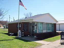
Dundee Post Office
|
|

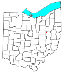
Location of Dundee, Ohio
|
|
| Country | United States |
| State | Ohio |
| County | Tuscarawas |
| Township | Wayne |
| Elevation | 1,027 ft (313 m) |
| Population
(2020)
|
|
| • Total | 269 |
| Time zone | UTC-5 (Eastern (EST)) |
| • Summer (DST) | UTC-4 (EDT) |
| ZIP code |
44624
|
| GNIS feature ID | 2628886 |
Dundee is a small community located in Ohio, United States. It's known as a census-designated place, which means it's an area identified by the government for gathering population data, but it's not officially a city or town with its own local government.
Dundee is found in the central part of Wayne Township, within Tuscarawas County. It has its own post office and a ZIP code of 44624. You can find Dundee where two main roads meet: State Route 93 and State Route 516.
According to the 2020 census, 269 people live in Dundee.
History of Dundee
When Dundee Was Founded
Dundee was first planned and mapped out in 1847. This process is called "platting," which means creating a detailed map of a piece of land, showing its boundaries and how it's divided into lots.
Dundee's Post Office
The community has had a working post office since 1847. This means people in Dundee have been able to send and receive mail right from their own town for a very long time.
See also
 In Spanish: Dundee (Ohio) para niños
 | Delilah Pierce |
 | Gordon Parks |
 | Augusta Savage |
 | Charles Ethan Porter |

