Dustin Island facts for kids
|
Location in Antarctica
|
|
| Geography | |
|---|---|
| Location | Ellsworth Land, Antarctica |
| Coordinates | 72°34′S 94°48′W / 72.567°S 94.800°W |
| Length | 33 km (20.5 mi) |
| Administration | |
| Administered under the Antarctic Treaty System | |
| Demographics | |
| Population | Uninhabited |
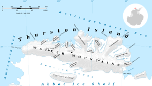
Dustin Island is an island located in the icy continent of Antarctica. It is about 33 kilometers (18 nautical miles) long. This island lies about 28 kilometers (15 nautical miles) southeast of Cape Annawan, which is part of Thurston Island. Dustin Island marks the southeastern edge of a place called Seraph Bay.
Discovering Dustin Island
Dustin Island was first spotted by a famous explorer named Rear Admiral Richard E. Byrd. He and his team from the United States Antarctic Service (USAS) discovered it on February 27, 1940. They saw the island during a flight from their ship, the Bear.
Who is Frederick G. Dustin?
The island was named by Byrd himself. He named it after Frederick G. Dustin. Frederick Dustin was an important member of Byrd's earlier Antarctic expedition from 1933 to 1935. He also worked as a mechanic with the USAS from 1939 to 1941. Naming the island after him was a way to honor his contributions to Antarctic exploration.
Where is Dustin Island Located?
Dustin Island is found in a region of Antarctica known as Ellsworth Land. Like most of Antarctica, it is uninhabited, meaning no people live there permanently. The entire continent of Antarctica is managed under the Antarctic Treaty System. This treaty ensures that the land is used for peaceful, scientific purposes only.
 | Delilah Pierce |
 | Gordon Parks |
 | Augusta Savage |
 | Charles Ethan Porter |


