Dutchtown, Missouri facts for kids
Quick facts for kids
Dutchtown, Missouri
|
|
|---|---|

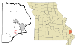
Location of Dutchtown, Missouri
|
|
| Country | United States |
| State | Missouri |
| County | Cape Girardeau |
| Area | |
| • Total | 1.78 sq mi (4.61 km2) |
| • Land | 1.78 sq mi (4.61 km2) |
| • Water | 0.00 sq mi (0.00 km2) |
| Elevation | 354 ft (108 m) |
| Population
(2020)
|
|
| • Total | 163 |
| • Density | 91.62/sq mi (35.37/km2) |
| Time zone | UTC-6 (Central (CST)) |
| • Summer (DST) | UTC-5 (CDT) |
| ZIP code |
63745
|
| Area code(s) | 573 |
| FIPS code | 29-20566 |
| GNIS feature ID | 0731565 |
Dutchtown is a place in Cape Girardeau County, Missouri, in the United States. It used to be a small village. In 2020, about 163 people lived there. It is located where two main roads, Route 25 and Route 74, meet.
Contents
History of Dutchtown
Early Settlers and Names
Dutchtown has a long history. People have lived there for many years. In 1801, a soldier named Martin Rodner moved his family to this area. He was a Hessian soldier, which means he came from a German state and fought for the British during the American Revolutionary War.
Martin Rodner owned a water mill on Hubble Creek. His neighbors found his name hard to say, so they called him "Rodney." His mill became known as Rodney's Mill. He passed away in 1827.
In the mid-1830s, families from Switzerland and Germany started settling near Rodney's Mill. They first named their settlement Spencer. Later, it became known as Dutchtown. This name came from the word "Deutsch," which means German.
The small village grew over time. A blacksmith and a bricklayer came to live and work there. A road called Bloomfield Road and railroad tracks also ran through the town.
The Church and the Swamp
In 1799, an important religious event happened near what is now Dutchtown. The first Protestant sermon and baptism west of the Mississippi River took place in Randol Creek.
In 1836, the German Evangelical Church was started in Dutchtown. It was an active church until around 1900. The first church building was made of logs. A new brick church was built in 1887. This church building is still there today. It also has a cemetery with about 150 gravestones.
People sometimes called it the "Swamp Church." This was because the village was built right next to a swampy area.
Flooding Problems and Disincorporation
Dutchtown officially became a village in February 1998. This happened after residents asked for it. However, the village had a big problem with flooding. There were many floods in 1973, 1993, 1995, 1998, 2002, 2011, 2013, 2016, and 2017.
Because of the constant flooding, many people decided to move away. They even received help from the government to buy their homes. On March 15, 2018, Dutchtown stopped being an official village. All of its property and responsibilities were given to Cape Girardeau County.
Geography
Dutchtown is located at coordinates 37°15′8″N 89°39′29″W / 37.25222°N 89.65806°W. This tells us its exact spot on a map.
The United States Census Bureau says that Dutchtown covers a total area of about 0.52 square miles (1.35 square kilometers). All of this area is land.
Population Facts
| Historical population | |||
|---|---|---|---|
| Census | Pop. | %± | |
| 1880 | 68 | — | |
| 2000 | 99 | — | |
| 2010 | 94 | −5.1% | |
| 2020 | 163 | 73.4% | |
| U.S. Decennial Census 2020 | |||
In 2010, there were 94 people living in Dutchtown. These people lived in 33 homes, and 24 of these were families. The population density was about 180 people per square mile (70 people per square kilometer). This means how many people live in a certain area.
About 30.9% of the people were under 18 years old. About 16% were 65 years old or older. The average age in the village was 27.5 years. The number of males and females was almost equal.
Education
Most of the children in Dutchtown go to schools in the Cape Girardeau School District. This district includes Central High School. A small part of Dutchtown is in the Delta R-V School District.
See also
 In Spanish: Dutchtown (Misuri) para niños

