Dyar site facts for kids
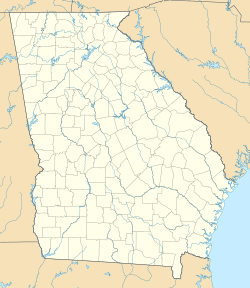
| Location | Greensboro, Georgia, Greene County, Georgia, |
|---|---|
| Region | Greene County, Georgia |
| Coordinates | 33°35′35.95″N 83°16′15.6″W / 33.5933194°N 83.271000°W |
| History | |
| Founded | 1100 |
| Abandoned | 1600 |
| Periods | Lamar Phase |
| Cultures | South Appalachian Mississippian culture |
| Site notes | |
| Excavation dates | 1969 |
| Archaeologists | Chester DePratter |
| Architecture | |
| Architectural styles | platform mound, plaza |
| Architectural details | Number of temples: 1 |
The Dyar site (also known as 9GE5) is an ancient place where people once lived. It is located in Greene County, Georgia, in the United States. This site covers an area of about 2.5 hectares, which is like 5 football fields.
People lived here almost all the time from the year 1100 to 1600. They were part of a group called the South Appalachian Mississippian culture. Even though the site is now under Lake Oconee, it is still very important. It was one of the first large Mississippian mounds to be studied by archaeologists. The Dyar site might have been a main town for a powerful leader, possibly a place called Cofaqui.
Contents
What Does the Dyar Site Look Like?
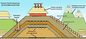
The Dyar site has a special type of earth mound called a platform mound. In 1975, this mound was described as being shaped like a cone with a flat top. It was about 10.3 meters (34 feet) tall and 52 meters (170 feet) wide at its base.
Next to the mound, on its eastern side, there was a large open area called a plaza. This plaza was surrounded by homes, forming an oval-shaped village. The village covered about 2.13 hectares.
How Was the Dyar Mound Built?
Platform mounds were not built all at once. They were made in many stages, sometimes over hundreds of years. Each stage added new layers of earth and often new buildings on top.
The Dyar mound started with a large building that had a sand floor. Over this, workers added layers of different colored clays and soils. Each new layer created a new "stage" of the mound. On top of these layers, new structures were built.
Archaeologists found pieces of pottery from different time periods in these layers. This helps them understand when each part of the mound was built. For example, pottery from the Stillhouse Phase was found in earlier layers.
Structures on the Mound
From stages VII to XIII, the western side of the mound had two large buildings. These buildings had special clay floors that were kept very clean. Early European visitors saw these deep floors and thought they were walls.
It is not clear if these two buildings were always connected by a walkway. Also, we don't know if both buildings were present in every stage. These buildings were rebuilt many times, even more often than new layers were added to the mound.
One of the buildings was used for important ceremonies. It had signs of a sacred fire and a special event called the black drink ceremony. The last building in this spot was burned around the year 1555. The other building, on the eastern side, was more like a home. People used it for preparing food, cooking, and possibly for big feasts.
The Dyar mound and its buildings were regularly rebuilt for over 500 years. There was only a short time in the 1300s when they were not rebuilt.
When Was the Dyar Site Used?
Archaeologists study how pottery styles changed over time to create a timeline for a region. The pottery found at the Dyar site shows that people lived there for a long time.
The site was used from the Stillhouse Phase (1100-1250 CE) until the time Europeans arrived. However, it seems the site was empty for a while during the Scull Shoals Phase (1250-1375 CE). People returned during the Duvall Phase (1375-1450 CE) and continued to live there through the Iron Horse and Dyar Phases.
| Phases | Dates | Periods | Pottery styles |
|---|---|---|---|
| Armour Phase | 950 - 1100 CE | Early Etowah | Before site occupation |
| Stillhouse Phase | 1100 - 1250 CE | Late Etowah | Etowah Complicated Stamped, Etowah Red Filmed, Savannah Check Stamped, Plain, Burnished Plain, and Coarse Plain |
| Scull Shoals Phase | 1250 - 1375 CE | Savannah | Site abandoned during this period |
| Duvall Phase | 1375 - 1450 CE | Early Lamar | Lamar var Plain, var Burnished Plain and var Coarse Plain but not var Incised, Morgan Incised, Etowah Complicated Stamped, and a stamped type which may be Savannah, Wilbanks, or Lamar Complicated Stamped. |
| Iron Horse Phase | 1450 - 1520 CE | Middle Lamar | Lamar var Plain, var Incised, var Complicated Stamped, Coarse Plain, and Burnished Plain. The marker for the phase is Lamar Incised |
| Dyar Phase | 1520 - 1580 CE | Late Lamar | Similar to preceding phase, which at one time were combined as one "Dyar phase". Incising of var Incised becomes finer over time |
| Bell Phase | 1580 - 1640 CE | Historic | There is little evidence for occupation of the site during this period |
How Was the Dyar Site Discovered and Studied?
People knew about the Dyar mound since the late 1800s. Some people even dug there without proper archaeological methods. But the first real study of the site happened in 1975.
A team led by Chester DePratter from the University of Georgia excavated the site. They received money from the Georgia Power Company. Even though the mound had been damaged by earlier digging, DePratter's team learned a lot. They found that Dyar was a unique and large Lamar mound and village site for the area.
Their research showed that the Dyar site was home to different groups of people over time. There were four main periods of occupation from 1100 to 1600: the Stillhouse phase, the Duvall phase, the Iron Horse phase, and the Dyar phase. The different styles of pottery found helped archaeologists tell these periods apart.
Pottery suggests that people from the Etowah chiefdom lived here during the Stillhouse phase. After the site was empty for a while, people from the Lamar Phase settled there in the 1400s. The site continued to be occupied by Lamar people until about 1555. It is thought that contact with Europeans might have led to the people slowly leaving the mound.
 | Valerie Thomas |
 | Frederick McKinley Jones |
 | George Edward Alcorn Jr. |
 | Thomas Mensah |


