Greene County, Georgia facts for kids
Quick facts for kids
Greene County
|
|
|---|---|

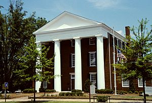
Greene County courthouse in Greensboro
|
|

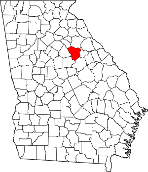
Location within the U.S. state of Georgia
|
|
 Georgia's location within the U.S. |
|
| Country | |
| State | |
| Founded | 1786 |
| Named for | Nathanael Greene |
| Seat | Greensboro |
| Largest city | Greensboro |
| Area | |
| • Total | 406 sq mi (1,050 km2) |
| • Land | 387 sq mi (1,000 km2) |
| • Water | 19 sq mi (50 km2) 4.6%% |
| Population
(2020)
|
|
| • Total | 18,915 |
| • Density | 49/sq mi (19/km2) |
| Time zone | UTC−5 (Eastern) |
| • Summer (DST) | UTC−4 (EDT) |
| Congressional district | 10th |
Greene County is a county located in the east-central part of Georgia, USA. It is also part of the "Lake Country" region. In 2020, about 18,915 people lived here. The main town and county seat is Greensboro. Greene County was created on February 3, 1786. It is named after Nathanael Greene, a very important general from the American Revolutionary War.
Contents
History of Greene County
Greene County was officially formed on February 3, 1786. The land for the county came from a larger area called Washington County. It was named to honor General Nathanael Greene. He was a brave hero during the American Revolutionary War.
Geography and Nature
The U.S. Census Bureau says that Greene County covers a total area of 406 square miles. About 387 square miles of this is land. The other 19 square miles (about 4.6%) is water.
Most of Greene County is located in the Upper Oconee River area. This river flows into the larger Altamaha River basin. The northern part of the county is in the Little River area. This river flows into the Savannah River basin. The southern part is in the Upper Ogeechee River area, which is part of the Ogeechee River basin.
Main Roads in Greene County
 Interstate 20
 U.S. Route 278
 State Route 12
 State Route 15
 State Route 44
 State Route 77
- State Route 402 (This is another name for I-20)
Neighboring Counties
Greene County shares borders with these other counties:
- Oglethorpe County (to the north)
- Taliaferro County (to the east)
- Hancock County (to the southeast)
- Putnam County (to the southwest)
- Morgan County (to the west)
- Oconee County (to the northwest)
Protected Natural Areas
A part of the Oconee National Forest is located within Greene County. This is a special area protected for nature.
Towns and Communities
Greene County has several towns and smaller communities.
Cities in Greene County
Towns in Greene County
Unincorporated Communities
These are smaller areas without their own city government:
- Bairdstown
Other Places of Interest
- Scull Shoals is a ghost town on the Oconee River. A ghost town is a place where people used to live, but now it is mostly empty.
People and Population
| Historical population | |||
|---|---|---|---|
| Census | Pop. | %± | |
| 1790 | 5,405 | — | |
| 1800 | 10,761 | 99.1% | |
| 1810 | 11,679 | 8.5% | |
| 1820 | 13,589 | 16.4% | |
| 1830 | 12,549 | −7.7% | |
| 1840 | 11,690 | −6.8% | |
| 1850 | 13,068 | 11.8% | |
| 1860 | 12,652 | −3.2% | |
| 1870 | 12,454 | −1.6% | |
| 1880 | 17,547 | 40.9% | |
| 1890 | 17,051 | −2.8% | |
| 1900 | 16,542 | −3.0% | |
| 1910 | 18,512 | 11.9% | |
| 1920 | 18,972 | 2.5% | |
| 1930 | 12,616 | −33.5% | |
| 1940 | 13,709 | 8.7% | |
| 1950 | 12,843 | −6.3% | |
| 1960 | 11,193 | −12.8% | |
| 1970 | 10,212 | −8.8% | |
| 1980 | 11,391 | 11.5% | |
| 1990 | 11,793 | 3.5% | |
| 2000 | 14,406 | 22.2% | |
| 2010 | 15,994 | 11.0% | |
| 2020 | 18,915 | 18.3% | |
| 2023 (est.) | 20,722 | 29.6% | |
| U.S. Decennial Census 1790-1880 1890-1910 1920-1930 1930-1940 1940-1950 1960-1980 1980-2000 2010 2020 |
|||
| Group | Number of People | Percentage |
|---|---|---|
| White (not Hispanic) | 11,126 | 58.82% |
| Black or African American (not Hispanic) | 5,783 | 30.57% |
| Native American | 28 | 0.15% |
| Asian | 174 | 0.92% |
| Pacific Islander | 2 | 0.01% |
| Other/Mixed | 513 | 2.71% |
| Hispanic or Latino | 1,289 | 6.81% |
In 2020, there were 18,915 people living in Greene County. These people lived in 7,132 households, which are like family units or groups of people living together.
Education in Greene County
Greene County has several schools and educational groups. These include the Greene County School Board. There are also two other schools: Lake Oconee Academy and Nathanael Greene Academy.
Helping People in Court
In 2001, the top judge in Georgia, Chief Justice Robert Benham, started a special committee. This committee looked into how people who could not afford a lawyer were helped in court. This is called "indigent defense."
There were many concerns about how this was handled in Greene County. People worried that some individuals were not getting fair help. The committee found that sometimes people were not properly represented in court.
After two years of looking into these issues, the committee made important suggestions. These suggestions led to a new law called the Georgia Indigent Defense Act. This law was created to make sure that everyone, even those who cannot afford a lawyer, gets fair legal help in court.
See also
 In Spanish: Condado de Greene (Georgia) para niños
 | Jackie Robinson |
 | Jack Johnson |
 | Althea Gibson |
 | Arthur Ashe |
 | Muhammad Ali |


