Putnam County, Georgia facts for kids
Quick facts for kids
Putnam County
|
|
|---|---|

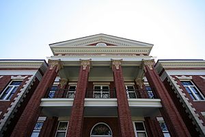
Putnam County courthouse in Eatonton
|
|

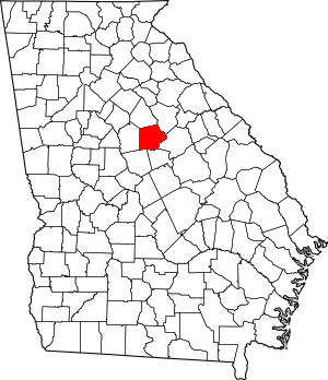
Location within the U.S. state of Georgia
|
|
 Georgia's location within the U.S. |
|
| Country | |
| State | |
| Founded | December 10, 1807 |
| Named for | Israel Putnam |
| Seat | Eatonton |
| Largest city | Eatonton |
| Area | |
| • Total | 361 sq mi (930 km2) |
| • Land | 345 sq mi (890 km2) |
| • Water | 16 sq mi (40 km2) 4.4%% |
| Population
(2020)
|
|
| • Total | 22,047 |
| • Density | 64/sq mi (25/km2) |
| Time zone | UTC−5 (Eastern) |
| • Summer (DST) | UTC−4 (EDT) |
| Congressional district | 10th |
Putnam County is a county located in the central part of the U.S. state of Georgia. As of the 2020 census, about 22,047 people lived there. The main town, also known as the county seat, is Eatonton.
Since the early 2000s, many new homes have been built in Putnam County. It is close to Lake Oconee, Lake Sinclair, and the Oconee River. These are all great places for outdoor fun. The county is also near big cities like Atlanta, Athens, and Macon, where many people work.
Contents
History of Putnam County
Putnam County is named after Israel Putnam. He was a brave hero in the French and Indian War. He also served as a general in the American Revolutionary War. After these wars, people from other parts of the southern United States moved here. The county was officially created on December 10, 1807. This happened thanks to a decision by the Georgia General Assembly.
After the cotton gin was invented, growing cotton became very popular. This machine made it much easier to process cotton. Large farms called plantations were set up in the county. Thousands of enslaved African Americans were forced to work on these farms.
In May 1919, there was a time of racial tension in the county. This was part of a larger period known as the Red Summer. During this time, several buildings belonging to the Black community were burned down. News reports said this happened after a small disagreement. Both Black and white groups of people were armed and afraid of each other.
From the 1920s to the 1960s, many Black people left Georgia. This movement was called the Great Migration. They moved to cities to find new jobs and better lives. The county's population dropped by more than half during this time. This was also because new machines helped with farm work, so fewer people were needed. Since the late 1900s, the number of people living in Putnam County has grown again.
Today, dairy farming is more important than cotton in Putnam County. The county even hosts a well-known event called the Dairy Festival every year.
Geography of Putnam County
Putnam County covers about 361 square miles. Most of this area, about 345 square miles, is land. The remaining 16 square miles, or 4.4%, is water. All of Putnam County is part of the Oconee River area. This river flows into the larger Altamaha River.
The county is located in the Piedmont region of Georgia. This area has rolling hills, many farms, and beautiful lakes. These features cover most of the county's land.
Major Roads in Putnam County
Counties Next to Putnam County
- Morgan County (north)
- Greene County (northeast)
- Hancock County (east)
- Baldwin County (southeast)
- Jones County (southwest)
- Jasper County (west)
Protected Natural Areas
- Part of the Oconee National Forest is in Putnam County.
Communities in Putnam County
City
Census-designated place
Unincorporated community
Population of Putnam County
| Historical population | |||
|---|---|---|---|
| Census | Pop. | %± | |
| 1810 | 10,029 | — | |
| 1820 | 15,475 | 54.3% | |
| 1830 | 13,261 | −14.3% | |
| 1840 | 10,260 | −22.6% | |
| 1850 | 10,794 | 5.2% | |
| 1860 | 10,125 | −6.2% | |
| 1870 | 10,461 | 3.3% | |
| 1880 | 14,539 | 39.0% | |
| 1890 | 14,842 | 2.1% | |
| 1900 | 13,436 | −9.5% | |
| 1910 | 13,876 | 3.3% | |
| 1920 | 15,151 | 9.2% | |
| 1930 | 8,367 | −44.8% | |
| 1940 | 8,514 | 1.8% | |
| 1950 | 7,731 | −9.2% | |
| 1960 | 7,798 | 0.9% | |
| 1970 | 8,394 | 7.6% | |
| 1980 | 10,295 | 22.6% | |
| 1990 | 14,137 | 37.3% | |
| 2000 | 18,812 | 33.1% | |
| 2010 | 21,218 | 12.8% | |
| 2020 | 22,047 | 3.9% | |
| 2023 (est.) | 23,129 | 9.0% | |
| U.S. Decennial Census 1790-1880 1890-1910 1920-1930 1930-1940 1940-1950 1960-1980 1980-2000 2010 |
|||
| Race | Num. | Perc. |
|---|---|---|
| White (non-Hispanic) | 14,316 | 64.93% |
| Black or African American (non-Hispanic) | 5,385 | 24.43% |
| Native American | 33 | 0.15% |
| Asian | 108 | 0.49% |
| Pacific Islander | 1 | 0.0% |
| Other/Mixed | 647 | 2.93% |
| Hispanic or Latino | 1,557 | 7.06% |
As of the 2020 United States census, there were 22,047 people living in Putnam County. These people made up 8,937 households and 6,282 families.
Education in Putnam County
The schools in Putnam County are managed by the Putnam County Charter School System.
See also
 In Spanish: Condado de Putnam (Georgia) para niños
 | Precious Adams |
 | Lauren Anderson |
 | Janet Collins |

