White Plains, Georgia facts for kids
Quick facts for kids
White Plains, Georgia
|
|
|---|---|
 |
|

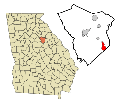
Location in Greene County and the state of Georgia
|
|
| Country | United States |
| State | Georgia |
| County | Greene |
| Area | |
| • Total | 5.21 sq mi (13.50 km2) |
| • Land | 5.17 sq mi (13.38 km2) |
| • Water | 0.05 sq mi (0.13 km2) |
| Elevation | 690 ft (211 m) |
| Population
(2020)
|
|
| • Total | 239 |
| • Density | 46.27/sq mi (17.87/km2) |
| Time zone | UTC-5 (Eastern (EST)) |
| • Summer (DST) | UTC-4 (EDT) |
| ZIP code |
30678
|
| Area code(s) | 706 |
| FIPS code | 13-82692 |
| GNIS feature ID | 0356635 |
White Plains is a small city located in Greene County, Georgia, in the United States. In 2020, about 239 people lived there.
Contents
What is the History of White Plains?
White Plains became an official city in 1834. This happened when the Georgia General Assembly (which is like the state's main law-making group) approved it. People say the city got its name because of the white, sandy soil found in the area.
Where is White Plains Located?
White Plains is in the southeastern part of Greene County. It is located at coordinates 33.477002 degrees North and 83.038404 degrees West. The city's southeast edge touches the border of Hancock County.
How to Get Around White Plains
Georgia State Route 15 is a main road that goes through the middle of White Plains. This road is also known as Old Greensboro Road. If you go north on State Route 15, you will reach Siloam in about 6 miles (9.7 km). If you travel south, you will get to Sparta in about 15 miles (24 km). Greensboro, which is the main town of Greene County, is about 12 miles (19 km) northwest on State Route 15.
How Big is White Plains?
The United States Census Bureau says that White Plains covers a total area of about 5.21 square miles (13.50 square kilometers). A very small part of this area, about 0.05 square miles (0.13 square kilometers), is water.
Who Lives in White Plains?
The city's population has changed over many years. Here is a look at how many people have lived in White Plains during different census years:
| Historical population | |||
|---|---|---|---|
| Census | Pop. | %± | |
| 1870 | 374 | — | |
| 1880 | 459 | 22.7% | |
| 1890 | 510 | 11.1% | |
| 1900 | 290 | −43.1% | |
| 1910 | 407 | 40.3% | |
| 1920 | 479 | 17.7% | |
| 1930 | 406 | −15.2% | |
| 1940 | 364 | −10.3% | |
| 1950 | 359 | −1.4% | |
| 1960 | 273 | −24.0% | |
| 1970 | 236 | −13.6% | |
| 1980 | 231 | −2.1% | |
| 1990 | 286 | 23.8% | |
| 2000 | 283 | −1.0% | |
| 2010 | 284 | 0.4% | |
| 2020 | 239 | −15.8% | |
| U.S. Decennial Census 1850-1870 1870-1880 1890-1910 1920-1930 1940 1950 1960 1970 1980 1990 2000 2010 2020 |
|||
What is the Population Makeup?
The table below shows the different groups of people living in White Plains. It looks at their race and ethnicity over the years. Remember, the US Census counts Hispanic/Latino people as an ethnic group, and they can be of any race.
| Race / Ethnicity (NH = Non-Hispanic) | Pop 2000 | Pop 2010 | Pop 2020 | % 2000 | % 2010 | % 2020 |
|---|---|---|---|---|---|---|
| White alone (NH) | 150 | 167 | 152 | 53.00% | 58.80% | 63.60% |
| Black or African American alone (NH) | 124 | 115 | 74 | 43.82% | 40.49% | 30.96% |
| Native American or Alaska Native alone (NH) | 0 | 0 | 0 | 0.00% | 0.00% | 0.00% |
| Asian alone (NH) | 0 | 0 | 0 | 0.00% | 0.00% | 0.00% |
| Native Hawaiian or Pacific Islander alone (NH) | 0 | 0 | 0 | 0.00% | 0.00% | 0.00% |
| Other race alone (NH) | 0 | 0 | 1 | 0.00% | 0.00% | 0.42% |
| Mixed race or Multiracial (NH) | 0 | 1 | 7 | 0.00% | 0.35% | 2.93% |
| Hispanic or Latino (any race) | 9 | 1 | 5 | 3.18% | 0.35% | 2.09% |
| Total | 283 | 284 | 239 | 100.00% | 100.00% | 100.00% |
In 2000, there were 283 people living in White Plains. These people lived in 108 households, and 72 of these were families. The city had about 61.5 people per square mile (23.7 people per square kilometer). There were also 126 houses, with about 27.4 houses per square mile (10.6 houses per square kilometer).
Most people in the city were White (about 55.83%) or African American (about 44.17%). About 3.18% of the population was Hispanic or Latino.
What are the Households Like?
Out of the 108 households, about 32.4% had children under 18 living there. About 41.7% were married couples living together. In 23.1% of households, a female was the head of the house without a husband present. About 33.3% of households were not families.
About 26.9% of all households had only one person living in them. About 13.9% of households had someone living alone who was 65 years old or older. On average, there were 2.62 people in each household and 3.28 people in each family.
What is the Age Range of Residents?
The population of White Plains was spread out by age. About 25.8% of residents were under 18 years old. About 9.9% were between 18 and 24 years old. The largest group, 31.1%, was between 25 and 44 years old. About 21.9% were between 45 and 64 years old. Finally, 11.3% were 65 years old or older. The average age in the city was 35 years.
For every 100 females, there were about 87.4 males. If you only look at females 18 and older, there were about 85.8 males for every 100 females.
What About Income?
In 2000, the average income for a household in White Plains was $33,906. For families, the average income was $36,136. Men earned an average of $22,143, while women earned an average of $15,781. The average income per person in the city was $12,328.
About 16.3% of families and 24.6% of all people in White Plains lived below the poverty line. This included 36.6% of those under 18 and 20.9% of those 65 or older.
See also
 In Spanish: White Plains (Georgia) para niños
 | Laphonza Butler |
 | Daisy Bates |
 | Elizabeth Piper Ensley |

