
East Branch Raven Creek facts for kids
Quick facts for kids East Branch Raven Creek |
|
|---|---|

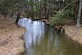
East Branch Raven Creek looking downstream
|
|
| Physical characteristics | |
| Main source | hill in east-central Benton Township, Columbia County, Pennsylvania between 1,160 and 1,180 feet (350 and 360 m) |
| River mouth | Raven Creek in south-central Benton Township, Columbia County, Pennsylvania 774 ft (236 m) 41°10′41″N 76°21′06″W / 41.17804°N 76.35163°W |
| Length | 3.7 mi (6.0 km) |
| Basin features | |
| Progression | Raven Creek → Fishing Creek → Susquehanna River → Chesapeake Bay |
| Basin size | 3.86 sq mi (10.0 km2) |
| Tributaries |
|
East Branch Raven Creek is a small stream, also called a tributary, located in Pennsylvania, USA. It flows through parts of Columbia County and Luzerne County. This creek is about 3.7 miles (6 km) long. It's special because it's home to brook trout and has a smaller stream called Stine Hollow joining it. The area of land that drains into this creek, called its watershed, is about 3.86 square miles (10 km²).
Contents
Where the Creek Flows

East Branch Raven Creek starts on a hill in Benton Township, Columbia County. It flows south for a bit, then turns southeast. For a short distance, it crosses into Luzerne County and goes through a small pond.
The creek then returns to Columbia County. It flows south-southwest, passing by a place called Hess Hill. It also goes under Pennsylvania Route 239. Further downstream, another small stream named Stine Hollow joins it. The creek then flows southwest along the base of Creveling Hill before joining Raven Creek.
Stine Hollow: A Tributary
East Branch Raven Creek has one main named tributary, which is Stine Hollow. A tributary is a smaller stream that flows into a larger one. Stine Hollow joins East Branch Raven Creek about 0.74 miles (1.2 km) before the main creek meets Raven Creek. The watershed for Stine Hollow is about 0.37 square miles (0.96 km²).
Water and Land Features
The amount of water flowing in East Branch Raven Creek each day is usually about 3.63 cubic feet per second. This is like filling a bathtub in a few seconds!
The creek starts at a high point, between 1,160 and 1,180 feet (350 to 360 meters) above sea level. Where it joins Raven Creek, the elevation is lower, about 774 feet (236 meters) above sea level.
East Branch Raven Creek is known as a freestone stream. This means its water flows over rocks and gravel, not through soft soil. It is also located near the edge of a glaciated plateau, which is a high, flat area shaped by ancient glaciers.
The Creek's Watershed
The entire area of land that collects water for East Branch Raven Creek, its watershed, is about 3.86 square miles (10 km²). The creek's source is in eastern Benton Township, and its mouth is in southern Benton Township. The creek is also close to the town of Stillwater, Pennsylvania.
This creek is part of a larger natural area called the Ridge-and-Valley Appalachians. This region is known for its long, parallel ridges and valleys.
History and Name
East Branch Raven Creek was officially recognized and added to the Geographic Names Information System in 1979. Scientists studied the creek in 1995 to learn more about the fish living there.
A concrete bridge was built over East Branch Raven Creek in 2006. This bridge is 25.9 feet (7.9 meters) long and carries Pennsylvania Route 239. It's located about 2.5 miles (4 km) east of Benton.
The creek gets its name from Raven Creek, which it flows into. Some people think Raven Creek might have once been called "Raving Creek." Another idea is that Raven Creek was named after a person nicknamed "Raven," possibly John Sutton.
Animals in the Creek
East Branch Raven Creek is a great place for brook trout. These fish are not only placed in the creek by people (stocked), but they also reproduce naturally there. This means the creek is a healthy home for them!
Images for kids
-
East Branch Raven Creek looking downstream
