Breitung Charter Township, Michigan facts for kids
Quick facts for kids
Breitung Township, Michigan
|
|
|---|---|
|
Charter township
|
|
| Charter Township of Breitung | |

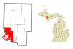
Location within Dickinson County (red) and the administered CDP of Quinnesec (pink)
|
|
| Country | United States |
| State | Michigan |
| County | Dickinson |
| Established | 1876 |
| Area | |
| • Total | 67.89 sq mi (175.83 km2) |
| • Land | 64.27 sq mi (166.46 km2) |
| • Water | 3.62 sq mi (9.38 km2) |
| Elevation | 1,161 ft (354 m) |
| Population
(2020)
|
|
| • Total | 5,831 |
| • Density | 91.1/sq mi (35.2/km2) |
| Time zone | UTC-6 (Central (CST)) |
| • Summer (DST) | UTC-5 (CDT) |
| ZIP code(s) | |
| Area code(s) | 906 |
| FIPS code | 26-10220 |
| GNIS feature ID | 1625974 |
Breitung Charter Township is a special kind of town area called a "charter township." It's located in Dickinson County, which is in the state of Michigan. In 2020, about 5,831 people lived there.
Contents
A Look Back: Breitung Township's History
Breitung Township got its name from a person named Edward Breitung. He was a miner and also served as a U.S. Representative for Michigan. This means he was elected to speak for Michigan in the national government. The township was officially started in 1876.
Where is Breitung Township? (Geography)
Breitung Township is a pretty big area. The total size is about 67.89 square miles (or 175.83 square kilometers). Most of this area, about 64.27 square miles (166.46 square kilometers), is land. The rest, about 3.62 square miles (9.38 square kilometers), is water, like lakes or rivers.
Communities in Breitung Township
Several communities are located within or very close to Breitung Township:
- The cities of Iron Mountain and Kingsford are in the southwest part of the township. However, they manage themselves and are not part of the township's government.
- East Kingsford is a part of the Kingsford city area. It is located just east of the city's border.
- Granite Bluff is a small, unincorporated community found between Merriman and Randville. An unincorporated community means it's not officially a city or town with its own local government.
- Merriman is another unincorporated community. It's located on M-95, which is a state highway, about seven miles north of Iron Mountain.
- Quinnesec is an unincorporated community that has been defined as a census-designated place. This means the U.S. Census Bureau counts it as a specific place for statistics. It's just east of Kingsford and Iron Mountain.
- Skidmore is also an unincorporated community in the township.
Who Lives in Breitung Township? (Demographics)
| Historical population | |||
|---|---|---|---|
| Census | Pop. | %± | |
| 2000 | 5,930 | — | |
| 2010 | 5,853 | −1.3% | |
| 2020 | 5,831 | −0.4% | |
| U.S. Decennial Census | |||
The population of Breitung Township has stayed pretty steady over the years.
- In 2000, there were 5,930 people living here.
- By 2010, the population was 5,853.
- In the most recent census (a count of all people), the population was 5,831.
This means that for every square mile of land, there were about 91 people living there in 2000.
See also
 In Spanish: Municipio de Breitung (Míchigan) para niños


