Edgewood Historic District–Aberdeen Plat facts for kids
Quick facts for kids |
|
|
Edgewood Historic District–Aberdeen Plat
|
|
 |
|
| Location | Berwick Ln., Chiswick Rd., Strathmore Place and Road, portions of Broad St., and Narragansett Blvd., Cranston, Rhode Island |
|---|---|
| Area | 27 acres (11 ha) |
| NRHP reference No. | 16000833 |
| Added to NRHP | November 22, 2016 |
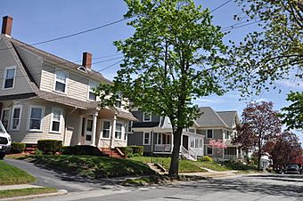
The Edgewood Historic District–Aberdeen Plat is a special area in the Edgewood neighborhood of Cranston, Rhode Island. It's known as a historic district because it has many old homes that show how people lived long ago. This area was built between 1901 and 1957. It used to be a large country estate. Later, it became a "streetcar suburb" for families who wanted to live outside the busy city but still travel easily by streetcar.
What is the Edgewood Historic District?
A historic district is a neighborhood with important old buildings. These buildings show how people lived in the past. The Edgewood Historic District–Aberdeen Plat is one such place. It is located in eastern Cranston, Rhode Island.
The district is bordered by Berwick Lane and Sefton Drive to the north. Broad Street is to the west. Chiswick Road is to the south. The Providence River is to the east. This area was added to the National Register of Historic Places in 2016. This means it is officially recognized as a place worth protecting for its history.
How Did This Area Develop?
In the late 1800s, this land was part of a large country estate. It belonged to Orray Taft, a well-known local businessman. His son, Edward Taft, later gave some of the land to the city. This land became Narragansett Boulevard and Stillman Cove Park.
At that time, a streetcar line ran along Broad Street. This line connected Pawtuxet village to the south with downtown Providence to the north. This made it easy for people to travel. Because of the streetcar, areas nearby started to become popular places to live. These were called "streetcar suburbs." People could live in a quieter area and still get to work or shops in the city.
In 1901, William M. Rhodes bought the rest of the Taft estate. He bought it in several parts. In 1902, Rhodes started the Aberdeen Land Company. This company planned out the neighborhood. They divided the land into smaller pieces for houses. This led to the development of the Edgewood Historic District.
What Does the District Look Like?
The Edgewood Historic District–Aberdeen Plat is next to another historic district. This is the Edgewood Historic District-Sally Greene Homestead Plats to the north. The houses in the Aberdeen Plat are on slightly larger lots. These lots are usually between 6,000 and 8,000 square feet.
Most of the homes are made of wood. They are usually one to two-and-a-half stories tall. Some houses have brick or stucco on the outside. The houses are set back a bit from the street. There is usually space on the sides for yards. Many homes also have garages, which were sometimes added later.
Almost all the buildings in the district are homes. There is one commercial building on Broad Street. Also, parts of Stillhouse Cove Park are within the district's borders.


