Egmont Islands facts for kids
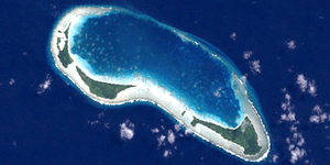
The Egmont Islands, also known as Egmont Atoll or Six Iles (which means "Six Islands" in French), are a group of islands that belong to the United Kingdom. These islands are part of the Chagos Archipelago, which is located in the British Indian Ocean Territory.
An atoll is a ring-shaped coral reef, island, or chain of islands that surrounds a lagoon (a body of saltwater). The Egmont Islands are one of the few atolls in the Chagos Archipelago that rise above the water.
This small atoll is about 10 kilometers (6 miles) south of a large underwater coral reef called the Great Chagos Bank. The Egmont Islands cover a total area of 29 square kilometers (11 square miles). This includes the lagoon and the coral reef around it. However, the actual land area of the islands is much smaller, only about 4 square kilometers (1.5 square miles). The closest island is Danger Island, which is less than 30 kilometers (18 miles) north.
There are two main openings that allow boats to enter the lagoon from the sea. These openings are on the northern side of the atoll. The Egmont Islands are a popular place for yachtsmen (people who sail yachts) to stop and anchor when they are traveling through the Chagos area.
The Islands of Egmont Atoll
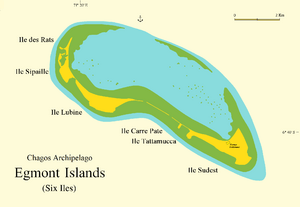
The Egmont Islands are made up of several smaller islands, all located on the southern edge of the coral reef. The largest island is called "Île Sud-Est," which means "Southeast Island." It is about 1.5 square kilometers (0.6 square miles) in size and was once home to a settlement. "Île Lubine" is also quite large, while the other islands are smaller. All the islands are covered with coconut trees.
Here are the names of the individual islands, listed from southeast to northwest:
- Île Sud-Est (Southeast Island)
- Île Takamaka (Takamaka Island)
- Île Carre Pate (Square Island)
- Île Lubine (Lubine Island)
- Île Cipaye (Cipaye Island)
- Île aux Rats (Rat Island)
There used to be a very small island called "Ilot aux Rats" (Islet with Rats) near Île aux Rats, but it has now joined with Île aux Rats. You might also see some of these island names spelled differently on maps, like 'Sipaille' or 'Cipaille' for Île Cipaye, 'Carpathe' for Île Carre Pate, and 'Tattamucca' for Île Takamaka.
History of the Egmont Islands
The largest island, Île Sud-Est, was first settled in the late 1700s. This was around the same time that other atolls in the Chagos Archipelago were settled by the French.
In 1838, a British naval officer named Commander Robert Moresby surveyed and mapped the atoll. At that time, there was a large coconut plantation on the islands. People had even built a raised road, called a causeway, to connect some of the islands. They also added more land by reclaiming it from the sea, which caused some of the islands to merge together over time.
The Egmont Islands became uninhabited in the second half of the 20th century. This happened when the Chagossians, also known as the Ilois, were moved from the Chagos Archipelago.
In 1972 and 1973, a special underwater expedition visited the Egmont Islands. This expedition was carried out by the Joint Services and was the first of its kind in the Chagos. The team studied how coral reefs form and grow, as well as the plants and animals living on the islands.
See also
 In Spanish: Islas Egmont para niños
 | Precious Adams |
 | Lauren Anderson |
 | Janet Collins |


