Eldorado, Sinaloa facts for kids
Quick facts for kids
Eldorado
|
|
|---|---|
| Country | |
| State | |
| Incorporated | 23 March 2021 |
| Seat | Eldorado |
| Area | |
| • Total | 586.56 km2 (226.47 sq mi) |
| Elevation
(of seat)
|
10 m (30 ft) |
| Population
(2020 Census)
|
|
| • Total | 46,628 |
| • Density | 79.4940/km2 (205.889/sq mi) |
| • Seat | 14,772 |
| Time zone | UTC-6 (Central) |
| Area code | 667 |
Eldorado is a new municipality in the Mexican state of Sinaloa. It is located about 55 kilometers (34 miles) south of Culiacán, the state capital. Eldorado officially became its own municipality on March 23, 2021. It will start operating as an independent municipality on November 1, 2024.
Contents
Exploring Eldorado's Location
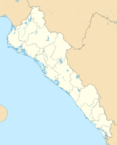
The municipality of Eldorado is found where the San Lorenzo River meets the sea in central Sinaloa. To the north and east, it shares borders with parts of the Culiacán municipality. These areas are called Costa Rica, Quilá, and Emiliano Zapata.
To the west, Eldorado is next to the Ensenada de Pabellones lagoon. This lagoon is a special Ramsar site, which means it's an important wetland. To the south, it borders the Gulf of California. Eldorado has a desert climate, which means it's usually hot and dry.
Eldorado's Weather
| Climate data for El Dorado weather station at 24°19′25″N 107°22′04″W / 24.32361°N 107.36778°W, 10 m above sea level (1981–2010 averages, 1951–2010 extremes) | |||||||||||||
|---|---|---|---|---|---|---|---|---|---|---|---|---|---|
| Month | Jan | Feb | Mar | Apr | May | Jun | Jul | Aug | Sep | Oct | Nov | Dec | Year |
| Record high °C (°F) | 36.0 (96.8) |
36.5 (97.7) |
38.0 (100.4) |
39.5 (103.1) |
42.5 (108.5) |
40.0 (104.0) |
41.0 (105.8) |
40.5 (104.9) |
41.5 (106.7) |
40.0 (104.0) |
37.5 (99.5) |
36.0 (96.8) |
42.5 (108.5) |
| Mean daily maximum °C (°F) | 28.9 (84.0) |
30.5 (86.9) |
31.2 (88.2) |
32.5 (90.5) |
34.1 (93.4) |
34.6 (94.3) |
36.0 (96.8) |
35.9 (96.6) |
35.6 (96.1) |
35.4 (95.7) |
32.9 (91.2) |
29.2 (84.6) |
33.1 (91.6) |
| Daily mean °C (°F) | 20.5 (68.9) |
21.7 (71.1) |
22.5 (72.5) |
24.2 (75.6) |
26.5 (79.7) |
29.3 (84.7) |
30.7 (87.3) |
30.6 (87.1) |
30.4 (86.7) |
28.7 (83.7) |
25.0 (77.0) |
21.1 (70.0) |
25.9 (78.6) |
| Mean daily minimum °C (°F) | 12.1 (53.8) |
12.8 (55.0) |
13.7 (56.7) |
15.9 (60.6) |
19.0 (66.2) |
24.1 (75.4) |
25.4 (77.7) |
25.3 (77.5) |
25.1 (77.2) |
22.0 (71.6) |
17.0 (62.6) |
13.1 (55.6) |
18.8 (65.8) |
| Record low °C (°F) | 4.0 (39.2) |
2.5 (36.5) |
5.5 (41.9) |
7.0 (44.6) |
10.0 (50.0) |
12.5 (54.5) |
19.5 (67.1) |
20.5 (68.9) |
19.0 (66.2) |
11.0 (51.8) |
4.5 (40.1) |
4.5 (40.1) |
2.5 (36.5) |
| Average precipitation mm (inches) | 11.4 (0.45) |
4.5 (0.18) |
3.0 (0.12) |
4.6 (0.18) |
0.4 (0.02) |
19.0 (0.75) |
61.6 (2.43) |
100.8 (3.97) |
149.6 (5.89) |
42.8 (1.69) |
24.5 (0.96) |
16.3 (0.64) |
438.5 (17.26) |
| Average precipitation days (≥ 0.1 mm) | 1.4 | 0.5 | 0.7 | 0.6 | 0.3 | 1.2 | 6.8 | 10.6 | 7.0 | 2.5 | 1.3 | 1.4 | 34.3 |
| Source: Servicio Meteorológico Nacional | |||||||||||||
Eldorado's History
Long ago, before the Spanish arrived, the area near Eldorado was home to the Sabaibo and Tahue peoples. Their settlement was called Navito. In 1531, a Spanish group led by Nuño de Guzmán reached Navito. They started a settlement nearby called San Miguel, but later moved it to where Culiacán is today.
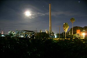
In 1856, Joaquín Redo y Balmaceda and his wife bought land near Navito. They built a textile factory and a sugar mill called La Aurora. In 1900, the Redo family built a new sugar mill. They named it Eldorado, and that's how the area got its name!
In 1917, Eldorado became a sindicatura, which is like a special administrative area within the larger Culiacán municipality. The famous writer Inés Arredondo used to spend her summer holidays in Eldorado when she was a child.
People started talking about Eldorado becoming its own independent municipality in the 1970s. It took many tries, but the idea gained strength again in 2020. Finally, on March 5, 2021, the Sinaloa state congress agreed. They voted to make Eldorado an independent municipality. The official rule making it a municipality started on March 23, 2021.
How Eldorado Will Be Governed
Eldorado will have its very first elections as an independent municipality in 2024. The local government will include a municipal president, a councillor (called a síndico in Spanish), and six trustees (called regidores). Three of these trustees will be chosen by getting the most votes, and three will be chosen based on how many votes their political parties get.
Eldorado is divided into four main administrative areas, also called sindicaturas. These areas are centered in the towns of Eldorado, Leopoldo Sánchez Celis, Las Arenitas, and Guadalupe Victoria.
People Living in Eldorado
In the 2020 Mexican Census, the areas that now make up the municipality of Eldorado had a total population of 46,628 people. The main town, also called Eldorado, had 14,772 people living there in 2020. The next biggest towns in the municipality are Leopoldo Sánchez Celis and Guadalupe Victoria. In 2020, Leopoldo Sánchez Celis had 3,411 people, and Guadalupe Victoria had 2,288 people.
Eldorado's Economy
Eldorado's economy depends on a few main things:
- Agriculture: Farmers use water from the San Lorenzo River to grow crops.
- Commerce: This means buying and selling goods in shops and markets.
- Fishing: Especially shrimp farming, which is very important here.
Sugar has been grown in Eldorado since 1900. The sugar mill in Eldorado is special because it's the only one still working in all of Sinaloa today!
Eldorado also has some beautiful beaches. These beaches are popular places for tourists to visit and enjoy.
See also
 In Spanish: Eldorado (Sinaloa) para niños


