El Limón, Aragua facts for kids
Quick facts for kids
El Limón
|
|||
|---|---|---|---|

Bolívar Square
|
|||
|
|||
| Country | |||
| State | Aragua | ||
| Municipality | Mario Briceño Iragorry Municipality | ||
| Area | |||
| • Total | 52.12 km2 (20.12 sq mi) | ||
| Elevation | 483 m (1,585 ft) | ||
| Population | |||
| • Total | 106,206 | ||
| • Demonym | Limonense | ||
| Time zone | UTC−4 (VET) | ||
| Postal code |
2105
|
||
| Climate | Aw | ||
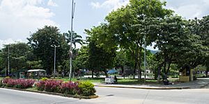
El Limón is a city located in the state of Aragua, Venezuela. It serves as the main town, or shire town, of the Mario Briceño Iragorry Municipality. For a long time, since early colonial days, El Limón was known for making cane sugar.
The city stayed quite small until the 1900s. However, in the second half of the 20th century, El Limón grew much bigger. Many factories and businesses were built, leading to significant industrial growth.
The El Limón River
The city gets its name from the El Limón River, which flows right through it. This river is a very important part of the city's geography.
The 1987 Flood
On September 6, 1987, the city experienced a very serious event. Heavy rains caused the El Limón River to overflow its banks. The floodwaters were powerful, carrying away roads, houses, and cars. This natural disaster had a major impact on the city and its people.
San Sebastian's Walk
El Limón is also famous for being the starting point of the annual San Sebastian's Walk. This long walk is a popular event that attracts many participants.
The Route of the Walk
The walk begins in El Limón and goes through the beautiful Henri Pittier National Park. This park is known for its amazing nature and wildlife. The journey covers a distance of 42 kilometers (about 26 miles). It finally ends in the town of Ocumare de la Costa.
See also
 In Spanish: El Limón (Venezuela) para niños
 | Ernest Everett Just |
 | Mary Jackson |
 | Emmett Chappelle |
 | Marie Maynard Daly |


