El Perelló facts for kids
Quick facts for kids
El Perelló
|
|||
|---|---|---|---|
|
Municipality
|
|||

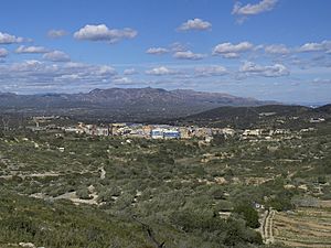
El Perelló with the Serra del Boix in the background
|
|||
|
|||
| Country | |||
| Community | |||
| Province | Tarragona | ||
| Comarca | Baix Ebre | ||
| Area | |||
| • Total | 100.7 km2 (38.9 sq mi) | ||
| Elevation | 142 m (466 ft) | ||
| Population
(2018)
|
|||
| • Total | 2,863 | ||
| • Density | 28.431/km2 (73.64/sq mi) | ||
| Demonym(s) | Perellonenc, perellonenca | ||
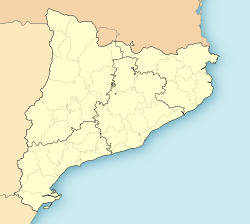
El Perelló is a small town, also known as a municipality, located in the Baix Ebre area of Catalonia, Spain. The word comarca means a region or district. El Perelló is found in the northern part of this region.
It sits below the beautiful Boix and Cabrafeixet mountain ranges. A main road, the N-340, goes around the town. This road connects El Perelló to the A-7 autopista at a place called l'Ampolla. An autopista is a large highway designed for fast travel.
How Many People Live Here?
This section talks about the demography of El Perelló. Demography is the study of how populations change over time.
The nearby town of l'Ampolla used to be part of El Perelló until 1990. In 2007, the total number of people living in both places combined was 2,895. The numbers below show only the population for the area that is El Perelló today.
| 1900 | 1930 | 1950 | 1970 | 1986 | 2007 |
|---|---|---|---|---|---|
| 4134 | 4408 | 4149 | 3556 | 3713 | 2895 |
See also
 In Spanish: Perelló para niños
 | Claudette Colvin |
 | Myrlie Evers-Williams |
 | Alberta Odell Jones |


