Eldorado Township, Benton County, Iowa facts for kids
Quick facts for kids
Eldorado Township
|
|
|---|---|

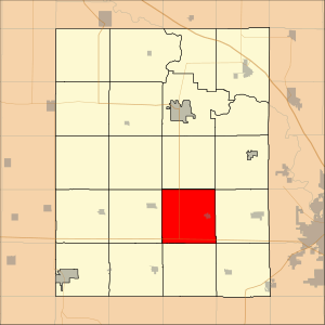
Location in Benton County
|
|
| Country | |
| State | |
| County | Benton |
| Area | |
| • Total | 92.21 km2 (35.6 sq mi) |
| • Land | 92.21 km2 (35.6 sq mi) |
| • Water | 0 km2 (0 sq mi) 0% |
| Elevation | 287 m (942 ft) |
| Population
(2000)
|
|
| • Total | 1,240 |
| • Density | 13.4/km2 (34.8/sq mi) |
| Time zone | UTC-6 (CST) |
| • Summer (DST) | UTC-5 (CDT) |
| ZIP codes |
52209, 52315, 52346, 52354
|
| GNIS feature ID | 0467771 |
Eldorado Township is a community located in Benton County, Iowa, in the United States. It is one of twenty townships in Benton County. In the year 2000, about 1,240 people lived there.
Contents
Geography
Eldorado Township covers an area of about 35.6 square miles (which is about 92.21 square kilometers). This information comes from the United States Census Bureau.
Towns and Villages
The township includes the town of Newhall.
Neighboring Townships
Eldorado Township is surrounded by several other townships:
- To the north: Eden Township
- To the northeast: Canton Township
- To the east: Fremont Township
- To the southeast: Florence Township
- To the south: St. Clair Township
- To the southwest: Leroy Township
- To the west: Union Township
- To the northwest: Big Grove Township
Cemeteries
There are three cemeteries located within Eldorado Township:
- Prairie Lutheran Cemetery
- Saint Johns Lutheran Cemetery
- Salem Cemetery
Major Roads
Important roads that pass through Eldorado Township include:
School Districts
Students in Eldorado Township attend schools within the Benton Community School District.
See also
 In Spanish: Municipio de Eldorado (Iowa) para niños

All content from Kiddle encyclopedia articles (including the article images and facts) can be freely used under Attribution-ShareAlike license, unless stated otherwise. Cite this article:
Eldorado Township, Benton County, Iowa Facts for Kids. Kiddle Encyclopedia.
