Entrance Road facts for kids
Quick facts for kids
Wyoming Highway 110 |
||||
|---|---|---|---|---|
| Entrance Road | ||||
|
WYO 110 highlighted in red
|
||||
| Route information | ||||
| Maintained by WYDOT & NPS | ||||
| Length | 0.585 mi (0.941 km) | |||
| Existed | 1917–present | |||
| Major junctions | ||||
| East end | ||||
| West end | Devils Tower National Monument Entrance | |||
| Location | ||||
| Counties: | Crook | |||
| Highway system | ||||
State highways in Wyoming
|
||||
|
Entrance Road--Devils Tower National Monument
|
||||
| Area | 3 miles (4.8 km) | |||
| Built | 1934 | |||
| Architect | NPS Branch of Plans and Design | |||
| MPS | Devils Tower National Monument MPS | |||
| NRHP reference No. | 00000854 | |||
| Added to NRHP | July 24, 2000 | |||
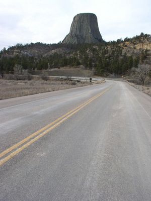
The Entrance Road is a special road that leads to the amazing Devils Tower National Monument in Wyoming. It's also known as Wyoming Highway 110. This short, scenic road is only about .585-mile-long (0.941 km). It was designed to give visitors awesome views of Devils Tower as they arrive.
What is the Entrance Road like?
Wyoming Highway 110 is a short road, about 0.59-mile-long (950 m). It starts at Wyoming Highway 24 and goes west. This road takes you right to the entrance of Devils Tower National Monument. As you drive, you'll notice the mile markers increase from east to west.
The entire entrance road is about 3-mile (4.8 km) long. It has two lanes and is paved with asphalt. This road connects the park's entrance station to the main visitor parking area. It also gives you access to important places like the park headquarters and the visitor center.
How was the Entrance Road built?
The original road was built in 1917. It was quite steep and had a river crossing where cars had to drive through the water. In 1928, a bridge was built to make the crossing easier.
A lot of changes happened in the 1930s. Workers from the Civilian Conservation Corps (CCC) greatly improved the road. They made it less steep and straightened out some curves. The CCC was a program during the Great Depression that gave young men jobs. CCC camp NM-1 was at Devils Tower from 1935 to 1938.
The National Park Service had big plans in 1927 for a complete loop road, but it was never built. The Entrance Road at Devils Tower is special because it blends so well with nature. It's even listed on the National Register of Historic Places.
The CCC workers did a great job making the new road. They carefully removed the old road sections. They used young trees and grass that they had saved to cover up the old paths. This helped the area look natural again.


