Erding (district) facts for kids
Quick facts for kids
Erding
|
||
|---|---|---|
|
||
| Country | ||
| State | Bavaria | |
| Adm. region | Upper Bavaria | |
| Region | Munich | |
| Capital | Erding | |
| Area | ||
| • Total | 870.44 km2 (336.08 sq mi) | |
| Population
(2000)
|
||
| • Total | 130,238 | |
| • Density | 149.6232/km2 (387.522/sq mi) | |
| Time zone | UTC+1 (CET) | |
| • Summer (DST) | UTC+2 (CEST) | |
| Vehicle registration | ED | |
| Website | landkreis-erding.de | |
Erding is a special kind of area in Bavaria, Germany, called a Landkreis or district. Think of it like a county in some other countries. It's a place where many towns and villages work together. The main town and capital of this district is also called Erding.
What is the Erding District?
The Erding district is located in the German state of Bavaria. It's part of a larger region called Upper Bavaria. The district covers about 870 square kilometers (which is about 336 square miles). In the year 2000, around 130,000 people lived there.
Towns and Villages in Erding
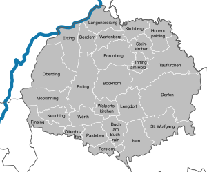
The Erding district is made up of different towns and smaller communities called municipalities. Each of these places has its own local government, but they all work together as part of the larger Erding district.
Here are the towns and municipalities you can find in the Erding district:
Towns
- Dorfen
- Erding
Municipalities
- Berglern
- Bockhorn
- Buch am Buchrain
- Eitting
- Finsing
- Forstern
- Fraunberg
- Hohenpolding
- Inning am Holz
- Isen
- Kirchberg
- Langenpreising
- Lengdorf
- Moosinning
- Neuching
- Oberding
- Ottenhofen
- Pastetten
- Sankt Wolfgang
- Steinkirchen
- Taufkirchen (Vils)
- Walpertskirchen
- Wartenberg
- Wörth
See also
 In Spanish: Distrito de Erding para niños
 | Selma Burke |
 | Pauline Powell Burns |
 | Frederick J. Brown |
 | Robert Blackburn |


