Erldunda facts for kids
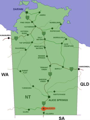
Erldunda is a very large area of land in Australia's Northern Territory. It's like a huge farm, called a cattle station, where thousands of cattle are raised. Erldunda is about 200 km (120 mi) (124 miles) south of Alice Springs.
A Look Back: Erldunda's History
Erldunda was started in the 1870s by a person named Richard Warburton. He brought the first cattle there in 1884. The Warburton family owned Erldunda until the 1920s. After that, the Stanes family bought the property.
Where is Erldunda?
Erldunda covers a huge area of about 1,200 square miles (3,108 km2), which is roughly 3,100 square kilometers. In 2010, about 6,500 Santa Gertrudis cattle lived there.
Erldunda shares its borders with other large cattle stations. These include Lyndavale to the west and Mount Ebenezer to the north. There are also Idracowra to the east and Umbeara to the south. Two creeks, Karinga Creek and Kalamurta Creek, flow through the property. These creeks only have water after it rains. In 2019, the Stanes family also owned Lyndavale and Mount Ebenezer.
Native Title: Sharing the Land
In April 2023, an important decision was made by the Federal Court of Australia. This decision was about native title for the Anangu people. They had asked for their traditional rights over about 10,000 km2 (3,900 sq mi) (3,861 square miles) of land. This land includes Erldunda, Lyndavale, and Curtin Springs stations.
This court ruling was the first time that commercial rights were recognized for traditional owners in Central Australia. The judge, Mordy Bromberg, announced the decision in a remote community called Imanpa. The ruling gave the traditional owners the right to hunt and perform special ceremonies on the land. It also means they must be asked for their opinion about how the land is used.
However, neither the traditional owners nor the cattle station owners have rights over mining for minerals. Licenses for mining potash are held over the lakes in the area. Ross Stanes, one of the station owners, said he was happy with the decision. He mentioned that his family has had a "long, long relationship" with the Anangu people. He also said that both the station owners and the traditional owners respect each other's rights. This shows how different groups can work together to share the land.
 | Sharif Bey |
 | Hale Woodruff |
 | Richmond Barthé |
 | Purvis Young |


