
Estherton, Pennsylvania facts for kids
Quick facts for kids
Estherton, Pennsylvania
|
|
|---|---|

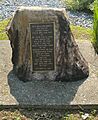
Boulder in Estherton, PA, once signifying where the town was laid in 1756. It was moved from its original location along the riverfront and rededicated in 1991.
|
|

Estherton, Pennsylvania
Location in Pennsylvania

Estherton, Pennsylvania
Location in the United States
|
|
| Country | United States |
| State | Pennsylvania |
| County | Dauphin |
| Township | Susquehanna |
| Time zone | UTC-5 (Eastern (EST)) |
| • Summer (DST) | UTC-4 (EDT) |
| ZIP codes |
17110
|
| Area code(s) | 717 and 223 |
Estherton is a small community or neighborhood in Susquehanna Township, Dauphin County, Pennsylvania, United States. It is part of the larger Harrisburg-Carlisle area. Estherton sits right next to the Susquehanna River, just north of the city of Harrisburg. A major highway, Interstate 81, goes through Estherton, leading to the George N. Wade Memorial Bridge.
Contents
History of Estherton
Estherton was first established in 1756. It was originally called Coxestown or Coxtown. Dr. John Cox Jr. founded the town and named it after his wife, Esther. It was the second town ever planned in Dauphin County.
Estherton's Role in Early America
In 1779, Estherton played an important role during the Sullivan Expedition. This was a military campaign during the American Revolutionary War. The town served as a place where supplies were stored for the soldiers. It also became a busy "port of call." This means it was a regular stop for boats and rafts carrying goods down the river.
Community and Landmarks
In 1800, Methodist families in Coxestown started the Coxestown Methodist Episcopal Church. This church moved and changed its name several times over the years. Today, it is known as St. Marks United Methodist Church.
Before 1828, a place called the "Coxestown Inn" was built. It was a popular stop for people traveling by the river. This inn was a well-known spot for many years until it burned down in 1926.
Modern Development
In the early 1970s, a major change came to Estherton. Interstate 81, a large highway, was built right through the area. This highway connects Estherton to other parts of Pennsylvania and beyond.
Images for kids
-
This boulder in Estherton marks where the town was founded in 1756. It was moved and rededicated in 1991.
