Fairmount, Richmond, Virginia facts for kids
|
Fairmount Historic District
|
|

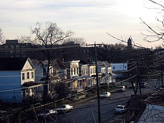
A street in the Fairmount Historic District.
|
|
| Location | Roughly bounded by 24th, Y, 20th, T, R, Q & P Sts., Fairfield & Carrington Aves., & Mechanicsville Tpk., Richmond, Virginia |
|---|---|
| Area | 99 acres (40 ha) |
| Built | 1890 |
| Architect | Wright, Cain, Robinson, Huntt, Wise; Pollard, James Fox and Son |
| Architectural style | Italianate, Queen Anne, Bungalow Craftsman |
| NRHP reference No. | 08000075 |
Quick facts for kids Significant dates |
|
| Added to NRHP | February 19, 2008 |
The Fairmount neighborhood in Richmond, Virginia, is a historic area located just north of Union Hill. It's part of the larger Church Hill community. Fairmount started as a "trolley car suburb" around the late 1800s. This means people could easily travel to and from the city center using electric streetcars.
Most of Fairmount was built between the 1890s and the 1920s. Because of this, many buildings show popular styles from that time. You'll see homes built in the beautiful Queen Anne and Italianate designs. There are also many cozy bungalow homes from the 1920s. One of the oldest houses still standing might be a wooden frame house built before 1870. The Fairmount School is another important building in the neighborhood.
Fairmount's History
Fairmount became an official independent town on March 10, 1902. However, the area was already growing and developing between 1889 and 1893. In 1906, Fairmount became part of the city of Richmond. This process is called "annexation," which means one area officially joins another. Before this, Fairmount was part of Henrico County.
Where is Fairmount?
The Fairmount neighborhood has clear boundaries. It is generally east of Mosby Street and north of Carrington Avenue. To the west, it's near 24th and 25th Streets. It also extends towards Fairfield Avenue. If you look across Fairmount Avenue, the neighborhood covers most of the area east of the Brauers neighborhood and west of 24th Street.
Becoming a Historic District
In February 2008, Fairmount received a special honor. It was officially listed on the National Register of Historic Places as the Fairmount Historic District. This means the neighborhood is recognized for its important history and architecture. Being on this list helps protect the area's unique character.
You can explore more about Fairmount's history! The City of Richmond has a map of the historic district available online. The Virginia Department of Historic Resources also has the application that was used to get Fairmount listed. There's even an illustrated version that shares the neighborhood's story with cool maps and pictures.
 | Madam C. J. Walker |
 | Janet Emerson Bashen |
 | Annie Turnbo Malone |
 | Maggie L. Walker |


