
Firgas facts for kids
Quick facts for kids
Firgas
|
|||
|---|---|---|---|
|
|||

Municipal location in Gran Canaria
|
|||

Firgas
Location in Province of Las Palmas

Firgas
Location in Canary Islands

Firgas
Location in Spain, Canary Islands
|
|||
| Country | Spain | ||
| Autonomous Region | Canary Islands | ||
| Province | Las Palmas | ||
| Island | Gran Canaria | ||
| Area | |||
| • Total | 15.77 km2 (6.09 sq mi) | ||
| Elevation | 500 m (1,600 ft) | ||
| Population
(2018)
|
|||
| • Total | 7,491 | ||
| • Density | 475.02/km2 (1,230.3/sq mi) | ||
| Time zone | UTC+0 (GMT) | ||

.svg)
Firgas is a charming town and a municipality located in the northern part of Gran Canaria, one of the beautiful Canary Islands. It's part of the Province of Las Palmas in Spain. Firgas was founded a long time ago, in 1488.
This town is nestled in the mountains, about 13 kilometers (8 miles) west of Las Palmas, the island's capital. Firgas is known as the "balcony of the Atlantic" because it offers amazing views of the northern coast. It's also famous for its bottled water, which is produced right in the town! In 2018, about 7,491 people lived here.
Contents
Exploring Firgas Town
The heart of Firgas is its central square, called San Roque. Here you'll find the main church and the town hall. It's a great place to start your visit.
Cool Places to See
Firgas has several interesting squares to explore. One special spot is the Paseo de Gran Canaria. This area features a 30-meter (98-foot) tall waterfall. You can also see cool models of the different Canary Islands here.
Geography and Climate of Firgas
Firgas is located in the northern part of Gran Canaria. It's about 28 kilometers (17 miles) away from the island's capital city.
Where is Firgas Located?
Firgas shares its borders with a few other municipalities. These include Moya, Valleseco, Teror, and Arucas. Firgas is the smallest municipality on Gran Canaria, covering an area of 15.77 square kilometers (6.09 sq mi).
The main part of Firgas town is about 465 meters (1,526 feet) above sea level. While Firgas doesn't have a coastline, its lowest point is 41 meters (135 feet) high. This low point is found in the Quintanilla ravine, near Arucas. The highest point in Firgas is Pico de Osorio, which reaches 967 meters (3,173 feet) above sea level.
What's the Weather Like?
Firgas has a dry, semi-arid, and cool climate. The average temperature throughout the year is about 17.8 °C (64 °F). August is usually the warmest month, with an average of 21.8 °C (71.2 °F). January is the coolest, averaging 14.4 °C (57.9 °F).
When it comes to rain, Firgas gets about 268 millimeters (10.6 inches) of rain each year. November and December are the wettest months, with about 54 millimeters (2.1 inches) of rain. July and August are the driest, receiving only about 1 millimeter (0.04 inches) of rain.
Images for kids
-
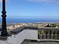
View from the San Roque town square.
-
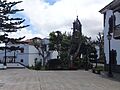
San Roque town square in Firgas.


See also
 In Spanish: Firgas para niños
