Ford, Wisconsin facts for kids
Quick facts for kids
Ford, Wisconsin
|
|
|---|---|

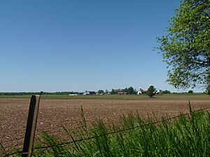
Farms in Ford
|
|

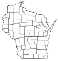
Location of Ford, Wisconsin
|
|
| Country | |
| State | |
| County | Taylor |
| Area | |
| • Total | 35.1 sq mi (90.8 km2) |
| • Land | 32.8 sq mi (84.9 km2) |
| • Water | 2.3 sq mi (6.0 km2) |
| Elevation | 1,260 ft (384 m) |
| Population
(2000)
|
|
| • Total | 276 |
| • Density | 8.4/sq mi (3.3/km2) |
| Time zone | UTC-6 (Central (CST)) |
| • Summer (DST) | UTC-5 (CDT) |
| Area code(s) | 715 & 534 |
| FIPS code | 55-26425 |
| GNIS feature ID | 1583212 |
| PLSS township | T31N R3W, roughly |
Ford is a small town located in Taylor County, Wisconsin, in the United States. In the year 2000, about 276 people lived there. A smaller community called Polley is also part of the town.
Contents
Geography of Ford
Ford covers about 35 square miles (90.8 square kilometers). Most of this area is land, but about 2.3 square miles (6.0 square kilometers) is water. A man-made lake called Chequamegon Waters, also known as Miller Dam, is found in the northeast part of Ford.
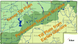
The ground in Ford is mostly made of a type of soil called silt loam, which has a heavy layer underneath. The southeast part of town has hilly areas. These hills were formed by the last glacier that moved through the area. The rest of Ford is flatter, also shaped by the same glacier. Rivers like the Yellow River and Hay Creek flow through these flat areas.
History of Ford
Early Surveys and Wilderness
In the mid-1800s, government workers explored and mapped the area that is now Ford. They walked through forests and swamps, measuring the land. In 1854, a surveyor described the area as having many swamps and being mostly flat. He noted that the land was covered with trees like hemlock and yellow birch. The Yellow River flowed through the area, and it was strong enough to power mills. At that time, there were no buildings or settlements in the township.
Logging and Early Roads
By 1880, a "winter road" was used to bring supplies to logging camps. This road followed the Yellow River and went deep into the wilderness. Loggers would cut down valuable white pine trees during the winter. In the spring, they would float the logs down the Yellow River in what were called log drives. A map from this time also shows a dam built in 1871 at the spot of today's Miller Dam.
Railroads and Polley Village
Between 1902 and 1903, the Stanley, Merrill and Phillips Railroad was built along the west side of Ford. It went north towards Jump River. Around 1905, another railroad, the Wisconsin Central, was built across the town. These two railroads crossed paths, and a small village called Polley grew up at this important junction.
Polley became a busy place with a sawmill, a hotel, a general store, a school, and even a newspaper. It was first called Morehouse, but later got its name Polley from a logger and postmaster named James Polley. Over time, some businesses moved to a nearby town called Gilman. The first railroad closed in the 1930s, and Polley became much smaller. Today, only a bar and a few homes remain there.
Land Ownership and Forest
A map from 1911 shows the railroads and how the land was owned. Large parts of Ford were owned by lumber companies. Some land in the south was owned by a company that helped people move to the area. At this time, there were very few settlers living in Ford. It was one of the last areas to be settled. In 1933, the eastern part of Ford became part of the Chequamegon National Forest.
The Stanley, Merrill and Phillips Railway stopped running in the 1930s. However, the Wisconsin Central line was taken over by the Canadian National Railway and is still in use today.
People of Ford
In 2000, there were 276 people living in Ford. The town had 96 households, and most of them (81) were families. On average, there were about 8 people living in each square mile.
- About 40% of households had children under 18 living with them.
- Most households (64.6%) were married couples.
- About 12.5% of households had people living alone.
- The average household had almost 3 people.
The people in Ford were of different ages:
- About 27% were under 18 years old.
- About 29% were between 25 and 44 years old.
- About 12% were 65 years or older.
The average age in Ford was 37 years.
The average income for a household in Ford was about $37,813 per year. For families, the average income was around $38,750. About 19.5% of the people in Ford lived below the poverty line. This included about 18% of those under 18 and 30% of those 65 or older.
See also
 In Spanish: Ford (Wisconsin) para niños
 | James B. Knighten |
 | Azellia White |
 | Willa Brown |


