Fort Seneca, Ohio facts for kids
Quick facts for kids
Fort Seneca, Ohio
|
|
|---|---|

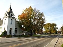
Fort Seneca as seen from Fremont-Tiffin Road, looking north on State Route 53.
|
|
| Country | United States |
| State | Ohio |
| County | Seneca County |
| Area | |
| • Total | 0.63 sq mi (1.62 km2) |
| • Land | 0.63 sq mi (1.62 km2) |
| • Water | 0.00 sq mi (0.00 km2) |
| Elevation | 699 ft (213 m) |
| Population
(2020)
|
|
| • Total | 230 |
| • Density | 366.83/sq mi (141.61/km2) |
| Time zone | UTC-5 (Eastern (EST)) |
| • Summer (DST) | UTC-4 (EDT) |
| ZIP code |
44883
|
| Area code(s) | 419 |
| GNIS feature ID | 2628892 |
Fort Seneca is a small community in Ohio, United States. It is officially known as a census-designated place (CDP). This means it is an area identified by the government for counting people. Fort Seneca is located in Seneca County. It sits on State Route 53, about 6 miles north of Tiffin. In 2020, about 230 people lived here.
Contents
History
A Fort from the War of 1812
Fort Seneca has an interesting history. A military fort was built nearby in July 1813. This happened during the War of 1812. General William Henry Harrison oversaw its construction. The community of Fort Seneca was later planned out in 1836. It was named after the old fort, which was about 2 miles away.
Post Office Services
Fort Seneca used to have its own post office. It opened on December 15, 1821. The post office had the ZIP code 44829. It served the community for many years until it closed in 1998.
Demographics
How Many People Live Here?
"Demographics" is a word that describes information about the people living in a place. This includes things like how many people there are. According to the 2020 census, the population of Fort Seneca was 230 people.
| Historical population | |||
|---|---|---|---|
| Census | Pop. | %± | |
| 2020 | 230 | — | |
| U.S. Decennial Census | |||
See also

- In Spanish: Fort Seneca (Ohio) para niños

