Kwadacha facts for kids
Quick facts for kids
Kwadacha
Fort Ware
|
|
|---|---|

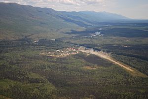
View of Kwadacha from above looking Southeast
|
|
| Country | Canada |
| Province | British Columbia |
| Population | |
| • Total | 350 |
| Area code(s) | 250, 778 |
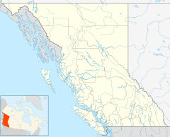
Kwadacha, also known as Fort Ware, is a small community in northern British Columbia, Canada. It's located in a valley called the Rocky Mountain Trench, where the Finlay, Kwadacha, and Fox Rivers meet. About 350 people live here.
Kwadacha is the home of the Kwadacha First Nation. These are Sekani people, and they are part of the Kaska Dena tribal council.
Contents
History of Kwadacha
The land around Kwadacha has always been the traditional territory of the Sekani-speaking people. They call this area Tahche.
Early Trading Post
In 1927, the Hudson's Bay Company (HBC) set up a trading post here. It was first called the Whitewater trading post. It was built to trade goods with the local Kwadacha people. The post also helped introduce them to commercial trapping, which is still an important way of life for the Kwadacha First Nation.
In 1938, the trading post was renamed Fort Ware. This was in honor of William Ware, who worked for the Hudson's Bay Company for many years. The HBC post closed down in 1953.
Relocation Due to Flooding
The original community of Fort Ware had to move. This happened in the late 1960s because of flooding from Williston Lake. This huge lake was created when the Bennett Dam was built on the Peace River in 1967.
Many people living in Fort Ware today are descendants of those who had to move. They came from places like Finlay Forks, which was also flooded when Lake Williston was created. Lake Williston is British Columbia's largest lake and one of the biggest man-made lakes in the world.
Getting Around and Connecting
Kwadacha is quite remote, meaning it's far away from big cities.
Transportation in Kwadacha
There are no major highways that reach Kwadacha. However, there is a logging road that connects the community to the Prince George area. Another logging road, about 70 kilometers long, links Kwadacha to the nearby Tsay Keh Dene village.
There are also old horse trails that follow the Rocky Mountain Trench north. These trails are not for vehicles and can take about two weeks to travel! A bridge has been built across the river on the south side of the village. Kwadacha also has a small public airport called Fort Ware Airport.
Communication Services
Telephone service came to Kwadacha in 1986. It was connected by satellite, allowing people to make long-distance calls. Around 2005, dial-up internet became available. However, there is no cell phone service in Kwadacha. Most air travel and phone calls go south towards Mackenzie and Prince George.
Geography and Nature
Kwadacha is surrounded by beautiful and rugged mountains.
Mountains and Parks
To the west of Kwadacha are the Omineca Mountains. These are part of the larger Stikine Ranges. Nearby, you'll find the Muskwa-Kechika Management Area and Kwadacha Wilderness Provincial Park. These areas are vast and wild, covering a huge part of the northern Rockies. They are even harder to reach than Kwadacha itself.
Climate in Kwadacha
Kwadacha has a varied climate with cold winters and mild summers.
| Climate data for Kwadacha (Fort Ware), elevation 777 m (2,549 ft) | |||||||||||||
|---|---|---|---|---|---|---|---|---|---|---|---|---|---|
| Month | Jan | Feb | Mar | Apr | May | Jun | Jul | Aug | Sep | Oct | Nov | Dec | Year |
| Record high °C (°F) | 3.9 (39.0) |
5.6 (42.1) |
11.1 (52.0) |
22.8 (73.0) |
27.8 (82.0) |
33.3 (91.9) |
30.0 (86.0) |
31.0 (87.8) |
27.2 (81.0) |
16.7 (62.1) |
10.6 (51.1) |
2.8 (37.0) |
33.3 (91.9) |
| Mean daily maximum °C (°F) | −15.2 (4.6) |
−6.4 (20.5) |
1.0 (33.8) |
7.8 (46.0) |
14.7 (58.5) |
19.4 (66.9) |
21.0 (69.8) |
20.1 (68.2) |
14.3 (57.7) |
6.0 (42.8) |
−4.8 (23.4) |
−11.3 (11.7) |
5.6 (42.0) |
| Daily mean °C (°F) | −19.9 (−3.8) |
−12.1 (10.2) |
−6.0 (21.2) |
1.3 (34.3) |
6.7 (44.1) |
11.4 (52.5) |
13.6 (56.5) |
12.8 (55.0) |
7.8 (46.0) |
1.1 (34.0) |
−8.4 (16.9) |
−15.2 (4.6) |
−0.6 (31.0) |
| Mean daily minimum °C (°F) | −24.4 (−11.9) |
−17.8 (0.0) |
−13.0 (8.6) |
−5.3 (22.5) |
−1.4 (29.5) |
3.4 (38.1) |
6.2 (43.2) |
5.4 (41.7) |
1.2 (34.2) |
−3.7 (25.3) |
−12.0 (10.4) |
−19.0 (−2.2) |
−6.7 (20.0) |
| Record low °C (°F) | −48.3 (−54.9) |
−44.0 (−47.2) |
−39.5 (−39.1) |
−20.6 (−5.1) |
−8.3 (17.1) |
−4.4 (24.1) |
−6.1 (21.0) |
−3.5 (25.7) |
−10.0 (14.0) |
−21.7 (−7.1) |
−35.6 (−32.1) |
−45.6 (−50.1) |
−48.3 (−54.9) |
| Average precipitation mm (inches) | 49.7 (1.96) |
38.1 (1.50) |
18.0 (0.71) |
14.7 (0.58) |
32.9 (1.30) |
44.3 (1.74) |
68.8 (2.71) |
48.5 (1.91) |
43.2 (1.70) |
27.9 (1.10) |
46.8 (1.84) |
60.3 (2.37) |
493.2 (19.42) |
| Average snowfall cm (inches) | 42.1 (16.6) |
30.3 (11.9) |
13.7 (5.4) |
6.9 (2.7) |
0.1 (0.0) |
0.0 (0.0) |
0.0 (0.0) |
0.0 (0.0) |
1.2 (0.5) |
9.2 (3.6) |
36.0 (14.2) |
47.0 (18.5) |
186.5 (73.4) |
| Average precipitation days | 10 | 9 | 5 | 4 | 7 | 9 | 13 | 10 | 10 | 10 | 10 | 13 | 110 |
| Average snowy days | 9 | 8 | 5 | 2 | 0 | 0 | 0 | 0 | 0 | 2 | 9 | 12 | 47 |
| Source: Environment and Climate Change Canada | |||||||||||||


