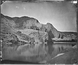
Fortification Rock facts for kids
Fortification Rock was once a famous hill next to the Colorado River. Today, it's known as Rock Island. It's the tallest and most southern of the Boulder Islands in Lake Mead, Clark County, Nevada.
This island stands 1,284 feet tall. Fortification Rock was first shown on a map in 1861. This map was made by Joseph Christmas Ives, a lieutenant who explored the Colorado River.
The Story of Fortification Rock
Before the Hoover Dam was built, Fortification Rock was a tall hill. It stood on the west bank of the Colorado River. This spot was just above the entrance to the Black Canyon of the Colorado.
How it Got its Name
A man named Joseph Christmas Ives named Fortification Rock. He was a 1st Lieutenant exploring the Colorado River. On March 11, 1858, he saw the rock. It looked like a strong fort to him, so he named it.
Exploring the River
Lieutenant Ives was trying to find out how far up the Colorado River large steamboats could travel. He thought Fortification Rock was the highest point steamboats could reach. This was especially true during the high-water season from June to October.
Ives had to leave his steamboat, the Explorer, behind. It had hit a rock called Explorer's Rock. While the steamboat was being fixed, Ives and his crew used a small boat called a skiff. They paddled up the canyon, carrying their boat over rapids. Two days later, they camped at the base of Fortification Rock. Ives climbed the rock to get a better view of the river and the land around it.
 | Selma Burke |
 | Pauline Powell Burns |
 | Frederick J. Brown |
 | Robert Blackburn |


