Freeburn, Kentucky facts for kids
Quick facts for kids
Freeburn
|
|
|---|---|

Freeburn
|
|

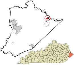
Location in Pike County and the state of Kentucky.
|
|
| Country | United States |
| State | Kentucky |
| County | Pike |
| Area | |
| • Total | 1.21 sq mi (3.13 km2) |
| • Land | 1.21 sq mi (3.13 km2) |
| • Water | 0.00 sq mi (0.00 km2) |
| Elevation | 725 ft (221 m) |
| Population
(2020)
|
|
| • Total | 296 |
| • Density | 245.03/sq mi (94.58/km2) |
| Time zone | Eastern (EST) |
| • Summer (DST) | EST |
| ZIP codes |
41528
|
| FIPS code | 21-29134 |
| GNIS feature ID | 492497 |
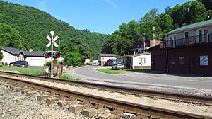
Freeburn is a small place in Pike County, Kentucky, Kentucky, United States. It is known as a census-designated place and an unincorporated community. This means it's a recognized area for counting people, but it doesn't have its own local government like a city or town.
Freeburn is also known as a coal town. This means it was a community built around the business of mining coal.
The community got its first post office in 1911. It was first called Liss. In 1932, its name was changed to Freeburn. People say the new name came from a "freeburning coal seam fire". This means there was a coal fire that burned easily on its own.
Climate in Freeburn
The weather in Freeburn has hot and humid summers. The winters are usually mild to cool. This type of weather is called a humid subtropical climate. On climate maps, you might see it marked as "Cfa". This climate is common in areas with warm temperatures and plenty of rain all year.
People in Freeburn
In 2020, the population of Freeburn was 296 people. This number comes from the 2020 United States Census. A census is like a big count of all the people living in a country.
More to Explore
 In Spanish: Freeburn (Kentucky) para niños
 | Aurelia Browder |
 | Nannie Helen Burroughs |
 | Michelle Alexander |

