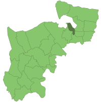
Friern Barnet Urban District facts for kids
| Friern Barnet Urban District | |
| Motto: RURIS AMATOR (Lover of the country) | |
| Friern Barnet town hall2.JPG | |
 |
|
| Geography | |
| Status | Local Government District (1883-1894) Urban District (1894-1965) |
| 1855 area | 1,292 acres (5.228km²) |
| 1874 area | 1,303 acres (5.273km²) |
| 1899 area | 1,304 acres (5.277km²) |
| 1914 area | 1,304 acres (5.277km²) |
| HQ | Parkhurst House, Friern Barnet Road, Friern Barnet (1884-1887) Tudor House, 18 Beaconsfield Road, Friern Barnet (1887-1906) The Priory, Friern Barnet (1906-1941) Friern Barnet Town Hall (1941-1965) |
| History | |
| Origin | Local Government Act 1858 |
| Created | 1883 |
| Abolished | 1965 |
| Succeeded by | London Borough of Barnet |
Quick facts for kids Demography |
|
|---|---|
| 1851 population | 974 |
| 1861 population | 1,335 |
| 1871 population | 4,347 |
| Politics | |
| Governance | Friern Barnet Local Board (1883-1894) Friern Barnet Urban District Council (1894-1965) |
| Subdivisions | |
| Type | Wards |
| Units | North, South, Central (1888-1945) North, South, East, West, Central (1945-1965) |
The Friern Barnet Urban District was a special area in Middlesex, England. It was created in 1883 from a place called Friern Barnet. This district was a type of local government area.
In 1965, the Friern Barnet Urban District became part of the larger London Borough of Barnet. It was one of the smaller areas that joined together to form the new borough. For its first nine years, a local board managed the district. After that, the Friern Barnet Urban District Council took over. This council handled most local matters, sometimes working with the Middlesex County Council for bigger plans.
Contents
Understanding Friern Barnet's Geography
The Friern Barnet area, which later became the district, stretched about 3 miles (5 km) from north to south. It started near the border with Hornsey parish, specifically its Muswell Hill part. The area was about half as wide as it was long.
To the north, the land gently sloped down towards the Dollis Brook. In the south, the land was lower, with a small stream called Bounds Green brook starting there.
Main Road and Settlements
The district had one main road running through it from end to end. This road is known today as the A1000 road. It was also part of the historic Great North Road, which connected London to Edinburgh.
Before the mid-1800s, Friern Barnet was a very old parish. It was once a medieval village that had lost most of its people. Only the manor house, barn, farm, and church remained. The area had two small groups of buildings: Whetstone in the far north and Colney Hatch in the south.
Over time, the local government changed. A "civil parish" was created, which took over many duties from the old church leaders. Soon after, the Friern Barnet Urban District was formed, and a Local Board took on most of these responsibilities. Some powers were also given to the Middlesex County Council.
How Friern Barnet Grew: The Impact of Railways
Like many areas around London, most of the houses in Friern Barnet were built after railways arrived. A lot of building happened between 1851 and the start of World War II.
New Southgate Station and Population Growth
The first railway station, New Southgate railway station, was built in 1851. It was located near Colney Hatch, close to the district's southeast border. This made it easier for people to travel to and from the area.
A second station, Totteridge & Whetstone tube station, opened in 1871. This station was a short distance from the northwest part of the district. It was on the High Barnet branch of the Northern Line underground train system. Having this station nearby made many people want to live in that part of the district.
You can see how much the population grew by looking at the numbers in the information box at the top of this page. The arrival of the railways led to a big increase in people moving to Friern Barnet.
 | James B. Knighten |
 | Azellia White |
 | Willa Brown |

