Whetstone, London facts for kids
Quick facts for kids Whetstone |
|
|---|---|
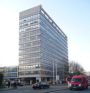
 Barnet House: previously Barnet council offices, originally the Ever-Ready building, dominates the centre of Whetstone. |
|
| OS grid reference | TQ265935 |
| London borough | |
| Ceremonial county | Greater London |
| Region | |
| Country | England |
| Sovereign state | United Kingdom |
| Post town | LONDON |
| Postcode district | N20 |
| Dialling code | 020 |
| Police | Metropolitan |
| Fire | London |
| Ambulance | London |
| EU Parliament | London |
| UK Parliament |
|
| London Assembly |
|
Whetstone (say it: WET-stone) is a part of London, located in the London Borough of Barnet. It has the postcode N20. You can get there by using the Underground station called Totteridge and Whetstone. Totteridge is a nearby area to the west.
Whetstone is about 7.8 miles north of Charing Cross, a famous spot in central London. It's a community within the London Borough of Barnet. Before the 1960s, it was part of the Borough of Finchley. The areas of Totteridge and Whetstone together were found to be one of the richest areas in the UK at the start of the 21st century.
The main road through Whetstone is the A1000. This road used to be known as the Great North Road. Some parts of it still have that old name. Until the late 1800s, Whetstone was one of two main settlements in the old parish of Friern Barnet. The other settlement was Colney Hatch.
Contents
Discovering Whetstone's Past
How Whetstone Got Its Name
In the Middle Ages, a group called the Hospitallers had a settlement near Friern Barnet. This was probably where Friary Park is today, close to the old road to London. In 1340, the Bishop of London opened a new gate into his park. This created a straight road across Finchley Common.
Because of this new road, the Hospitallers' settlement moved further west. It became known as West Town. Over time, its name changed to "le Weston," then "Wheston," and finally "Whetstonestret."
Whetstone was the northernmost settlement in the area known as the Ossulstone hundred. Until the late 1800s, Whetstone was a small developed area. It was one of two main places in the old parish of Friern Barnet. The other main place was Colney Hatch.
The Famous Whetstone
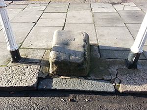
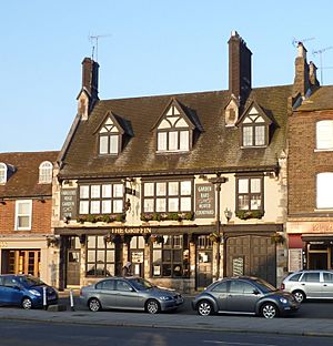
There is a special stone outside The Griffin public house in Whetstone. It is commonly known as "the Whetstone." A local historian, John Heathfield, says that this stone is actually a mounting block. Mounting blocks were used to help people get onto horses. If it was a mounting block, it might have been connected to a toll gate. This toll gate was set up around 1730 by the Whetstone & Highgate Turnpike Trust.
There is a cool legend about the Whetstone. It says that soldiers used the stone to sharpen their weapons. This happened when they were marching towards High Barnet. They were getting ready for the Battle of Barnet in 1471. High Barnet is about 3.5 miles north of Whetstone.
The earliest photo of the stone is from 1861. It shows the stone much closer to The Griffin pub than it is now. The stone was moved to its current spot in 1863. This was when the toll gate was removed.
Getting Around Whetstone
Whetstone has good ways to travel around. There is a national rail station called Oakleigh Park Station. It is about 1 mile east of Whetstone's main road. This station is on the Welwyn Garden City branch of the Thameslink network.
There is also a London Underground station called Totteridge and Whetstone. Many Transport for London (TFL) buses also serve the area. These buses go to places like Walthamstow, Highbury, High Barnet, and Trafalgar Square.
Some of the bus routes include:
- The 125 from Winchmore Hill to Colindale.
- The 234 from Barnet, The Spires to Archway.
- The 263 from Barnet Hospital to Highbury Barn.
- The 383 from High Barnet to Finchley Memorial Hospital.
- The 34 from Walthamstow to Barnet Church.
- The 251 from Arnos Grove to Edgware.
- The 326 from Brent Cross to High Barnet.
- The N20, a night bus, from High Barnet to Trafalgar Square.
Whetstone's Location and Nature
Whetstone is the northernmost part of an area called the Finchley plateau. It is located about 95 meters (312 feet) above sea level.
Swan Lane Open Space is a park in the south of Whetstone. The Dollis Valley Greenwalk is a path that follows the Dollis Brook. This path also goes through Swan Lane Open Space.
 |
Totteridge | Oakleigh Park | Osidge |  |
| Woodside Park | Brunswick Park | |||
| North Finchley | Friern Barnet | New Southgate |
Public Transport in Whetstone
Here are the main train and tube stations in the Whetstone area:
- Totteridge and Whetstone (on the Northern line)
- Oakleigh Park (on the Thameslink network)
 | Jackie Robinson |
 | Jack Johnson |
 | Althea Gibson |
 | Arthur Ashe |
 | Muhammad Ali |


