Frye Island, Maine facts for kids
Quick facts for kids
Frye Island, Maine
|
|
|---|---|
|
Town
|
|
| Motto(s):
"A Community Managed By Its Owners"
|
|

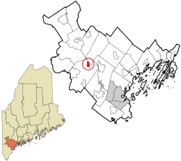
Location in Cumberland County and the state of Maine.
|
|
| Country | United States |
| State | Maine |
| County | Cumberland |
| Incorporated | July 1, 1998 |
| Named for | Joseph Frye |
| Area | |
| • Total | 1.60 sq mi (4.14 km2) |
| • Land | 1.34 sq mi (3.47 km2) |
| • Water | 0.26 sq mi (0.67 km2) |
| Elevation | 269 ft (82 m) |
| Population
(2020)
|
|
| • Total | 32 |
| • Density | 24/sq mi (9.2/km2) |
| Time zone | UTC−5 (Eastern (EST)) |
| • Summer (DST) | UTC−4 (EDT) |
| ZIP Code |
04071
|
| Area code(s) | 207 |
| FIPS code | 23-27025 |
| GNIS feature ID | 1802735 |
Frye Island is a unique island town in Cumberland County, Maine, United States. It is located in Sebago Lake. You can get to the island by a public car ferry from Raymond Neck or by private boat.
Most people who own homes on Frye Island visit only during certain seasons. Many property owners come from New England states like Maine, Massachusetts, and Connecticut. The island is usually empty from November through April. This is because thick ice blocks the ferry route during winter. Frye Island is part of the larger Portland metropolitan area. In 2020, the town had a population of 32 people.
Contents
History of Frye Island
Frye Island was once part of a larger land grant given in 1750. This grant was from the Massachusetts General Court. It was given to Captain Moses Pearson and Captain Humphrey Hobbs. They received it for their service in the French and Indian Wars. The area was first settled in the 1750s. Later, it became the town of Standish in 1785.
How Frye Island Became a Town
Frye Island is named after Captain Joseph Frye. The island decided to become its own separate town on July 1, 1998. This made it an independent town within Maine.
The Legend of Frye's Leap
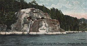
There's a famous story about Captain Frye on the island. The legend says he was being chased by Native Americans in Portland. He came to a huge rock, now called Frye's Leap. With no other way to go, Captain Frye bravely jumped from the rock. He then swam across the water to Frye Island to escape.
For many years, Frye's Leap was a popular spot for people to try to recreate Captain Frye's famous jump. However, the cliffs are sharp and dangerous. Many serious injuries were reported each summer. Because of these dangers, "No Trespassing" signs were placed along the cliff edge. On warm summer days, the Maine Warden Service often patrols the area. This helps to keep people safe and prevent jumping.
Life on Frye Island
Frye Island has about 1,000 acres of mostly wooded land. It has 22 miles (35 km) of dirt roads. The speed limit on the island is 20 miles per hour (32 km/h). The most popular way to get around is by golf cart, not by car. Many homes are built right on the waterfront, offering views of Sebago Lake.
Property values on Frye Island have increased a lot recently. Waterfront homes are especially valuable. The island has two marinas where boats can dock. There are also various sports and recreation facilities. You can find several public beaches, a convenience store, and an ice cream stand. There is also a restaurant with a bar and a golf club with a lounge open to everyone.
Getting to the Island: The Ferry
The island is reached by two 65-foot (20 m) car ferries. The town owns and operates these ferries. They run every half-hour during July and August, from early morning until late evening. The schedule is a bit less frequent during the off-season. The ferry trip across the water takes about 7 minutes. People can walk onto the ferry, but there is no parking for passengers at the ferry landings.
Island Traditions and Celebrations
Independence Day is the biggest holiday celebrated on Frye Island. It is known for its fun golf cart parade. There is also a fantastic fireworks display. People from all over Sebago Lake gather to watch the fireworks. They watch from their boats or from the beach. Each year, a walk and run event is held, along with many other festive activities.
Geography of Frye Island
Frye Island is about 1.5 miles (2.4 km) wide at its widest point. It is approximately 2.5 miles (4.0 km) long. The United States Census Bureau states that the town covers a total area of 1.60 square miles (4.14 km²). Of this, 1.34 square miles (3.47 km²) is land. The remaining 0.26 square miles (0.67 km²) is water. Frye Island is located entirely within Sebago Lake.
Population and Demographics
| Historical population | |||
|---|---|---|---|
| Census | Pop. | %± | |
| 2010 | 5 | — | |
| 2020 | 32 | 540.0% | |
| U.S. Decennial Census | |||
The population of Frye Island is quite small. In 2010, there were only five people living in the town. By 2020, the population had grown to 32 people. This shows that while it's a small community, more people are choosing to live there.
Population Details from 2010
In 2010, there were two households on the island. Both of these households were married couples living together. Half of these households had children under 18 living with them. The average household size was 2.50 people. The average family size was also 2.50 people.
The average age of residents in 2010 was 30.8 years. Twenty percent of the residents were under 18 years old. Forty percent were between 25 and 44 years old. Another forty percent were 65 years of age or older. The population was 60% male and 40% female.
See also
 In Spanish: Frye Island para niños
 | Calvin Brent |
 | Walter T. Bailey |
 | Martha Cassell Thompson |
 | Alberta Jeannette Cassell |


