Frying Pan Lake facts for kids
Quick facts for kids Frying Pan Lake |
|
|---|---|
 |
|
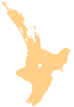
| Location | Waimangu Volcanic Rift Valley, North Island |
| Coordinates | 38°17′01″S 176°23′42″E / 38.28361°S 176.39500°E |
| Primary inflows | (hot spring) |
| Primary outflows | Waimangu Stream (Hot Water Creek) |
| Basin countries | New Zealand |
| Max. width | 200 m (660 ft) |
| Surface area | 3.8 ha (9.4 acres) |
| Average depth | 6 m (20 ft) |
| Max. depth | 20 m (66 ft) |
| Water volume | 200,000 m3 (160 acre⋅ft) |
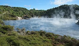
Frying Pan Lake is the world's largest hot spring. It is found in the Echo Crater of the Waimangu Volcanic Rift Valley in New Zealand. Its water is quite acidic and stays at a temperature of about 50–60 °C (122–140 °F). The lake covers a huge area of 38,000 square meters. While most of the lake is only about 6 meters deep, some parts can go down to 20 meters. In 1963, it was renamed Waimangu Cauldron, but most people still call it Frying Pan Lake.
Contents
How Frying Pan Lake Was Formed
Echo Crater was created during a massive volcanic eruption in 1886. This eruption happened at Mount Tarawera. It opened up several craters along a 17-kilometer crack in the ground. This crack stretched from Mount Tarawera towards the Southern Crater.
After the 1886 eruption, the bottom of Echo Crater partly filled with rainwater and hot water from underground. But the lake didn't reach its current size until a big eruption in Echo Crater on April 1, 1917. After that, hot springs filled the crater, and by mid-1918, Frying Pan Lake looked much like it does today.
Changes Over Time
The most recent eruption in Echo Crater happened on February 22, 1973. This event destroyed an area called Trinity Terrace on the lake's southeastern side. However, you can still see colorful rock terraces on the western shore.
To the north of the lake are the steaming Cathedral Rocks. These huge rocks are made of rhyolitic lava that is at least 60,000 years old. They used to be called Gibraltar Rock. But the 1917 eruption completely changed their shape. A steaming vent called the Devil's Blowhole, located in the northern wall of Echo Crater, also disappeared during that eruption.
What Makes the Lake's Water Special?
The water in Frying Pan Lake often looks like it's boiling. This is because gases like carbon dioxide and hydrogen sulphide bubble up to the surface. However, the lake's average temperature is about 55 °C (131 °F), so it's not actually boiling.
The lake and its outflow, Waimangu Stream (also known as Hot Water Creek), are quite acidic. They have an average pH level of 3.8. Interestingly, some hot springs and vents on the lake's bottom feed it with alkaline water, which has a pH of 8.2 to 8.7. This mix creates different pH levels throughout the lake. These different levels decide which types of algae can grow there. You might find blue-green algae called Mastigocladus laminosus or eukaryotic algae called Cyanidium caldarium.
A Rhythmic Connection
Frying Pan Lake is connected to another nearby lake called Inferno Crater Lake. Their hydrothermal system works in a unique cycle. Scientists have been studying this cycle since 1970. They installed equipment to monitor the water levels and outflow from both lakes.
The water levels and how much water overflows from both lakes follow a complicated rhythm. This rhythm repeats itself roughly every 38 days. When the water level and temperature of Inferno Crater Lake go up, the water level and outflow of Frying Pan Lake go down. It's like they are balancing each other out!
The amount of water flowing out of Frying Pan Lake has changed over time. In 1970, it was over 122 litres per second (4.3 cubic feet per second). Now, it's around 100 L/s (3.5 cu ft/s). This outflow also changes by up to 20 L/s (0.7 cu ft/s) as part of the 38-day cycle.
Visiting Frying Pan Lake
Frying Pan Lake is one of the first big attractions you'll see along the main Waimangu walking track. This track is even friendly for wheelchairs. The spot where the famous Waimangu Geyser used to be is also not far from the lake's northeastern shore.
 | Kyle Baker |
 | Joseph Yoakum |
 | Laura Wheeler Waring |
 | Henry Ossawa Tanner |


