Frystown, Pennsylvania facts for kids
Quick facts for kids
Frystown, Pennsylvania
|
|
|---|---|
 |
|
| Country | United States |
| State | Pennsylvania |
| County | Berks |
| Township | Bethel |
| Area | |
| • Total | 1.22 sq mi (3.17 km2) |
| • Land | 1.21 sq mi (3.14 km2) |
| • Water | 0.01 sq mi (0.03 km2) |
| Elevation | 466 ft (142 m) |
| Population
(2020)
|
|
| • Total | 355 |
| • Density | 292.66/sq mi (113.04/km2) |
| Time zone | UTC-5 (Eastern (EST)) |
| • Summer (DST) | UTC-4 (EDT) |
| ZIP codes |
17067 & 19507
|
| Area code(s) | 717 |
| FIPS code | 42-28128 |
| GNIS feature ID | 1175322 |
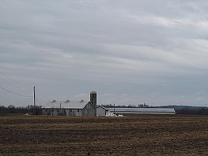
Frystown is a small community in Bethel Township, located in the western part of Berks County, Pennsylvania, United States. It is called a census-designated place, which means it's an area defined by the U.S. Census Bureau for collecting statistics. It is not an officially incorporated town.
Frystown is near the border with Tulpehocken Township. Students living in Frystown attend schools in the Tulpehocken Area School District.
Geography and Location
Frystown is located in a rural area of Pennsylvania. The Little Swatara Creek forms the southern edge of Frystown. This creek flows west and eventually joins the Swatara Creek. The Swatara Creek is a tributary (a smaller river or stream that flows into a larger one) of the Susquehanna River.
A major highway, Interstate 78, has an exit in Frystown where it connects with Route 645. This makes it easy to travel to and from the community.
Postal Services
Frystown uses two different ZIP codes for its mail. Parts of the community are served by the Myerstown post office, which uses ZIP code 17067. Other parts are served by the Bethel post office, using ZIP code 19507.
Population of Frystown
According to the 2010 census, Frystown had a population of 380 people. By the 2020 census, the population was 355 residents. This information helps us understand how the community has grown or changed over time.
See also
- In Spanish: Frystown para niños
 | John T. Biggers |
 | Thomas Blackshear |
 | Mark Bradford |
 | Beverly Buchanan |


