Fuente de Oro facts for kids
Quick facts for kids
Fuente de Oro
|
||
|---|---|---|
|
Municipality and town
|
||
|
||

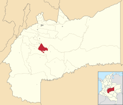
Location of the municipality and town of Fuente de Oro in the Meta Department of Colombia.
|
||
| Country | ||
| Department | Meta Department | |
| Area | ||
| • Total | 576 km2 (222 sq mi) | |
| Elevation | 359 m (1,178 ft) | |
| Population
(Census 2018)
|
||
| • Total | 11,599 | |
| • Density | 20.137/km2 (52.15/sq mi) | |
| Time zone | UTC-5 (Colombia Standard Time) | |
| Climate | Am | |
Fuente de Oro is a town and municipality located in the Meta Department of Colombia. Its name means "Fountain of Gold" in English. This town is an important part of the Meta Department, which is a region in central Colombia.
Location and Size
Fuente de Oro is found in the Meta Department, which is known for its vast plains and beautiful natural areas. The town is located about 359 meters (around 1,178 feet) above sea level.
The total area of the Fuente de Oro municipality is 576 square kilometers (about 222 square miles). To give you an idea, this is roughly the size of a medium-sized city, but it includes both the town and the surrounding rural areas.
Population
According to the 2018 census, about 11,599 people live in Fuente de Oro. This number includes people living in the main town and those in the countryside around it.
Climate and Weather
Fuente de Oro has a tropical monsoon climate, which means it's generally hot and humid all year round. There are distinct wet and dry seasons.
- Temperatures: The average temperature is around 25.4 degrees Celsius (about 77.7 degrees Fahrenheit). The highest temperatures are usually in January and February, while the lowest are in July.
- Rainfall: This area gets a lot of rain, especially from April to July. The driest months are December and January. The total rainfall for the year is quite high, over 2,300 millimeters (about 92 inches).
- Humidity: The air is quite humid throughout the year, usually around 84%.
This type of climate supports a rich variety of plants and animals, typical of tropical regions.
| Climate data for Fuente de Oro (Cooperativa La), elevation 280 m (920 ft), (1981–2010) | |||||||||||||
|---|---|---|---|---|---|---|---|---|---|---|---|---|---|
| Month | Jan | Feb | Mar | Apr | May | Jun | Jul | Aug | Sep | Oct | Nov | Dec | Year |
| Mean daily maximum °C (°F) | 32.0 (89.6) |
32.2 (90.0) |
31.7 (89.1) |
30.7 (87.3) |
30.3 (86.5) |
29.8 (85.6) |
29.7 (85.5) |
30.5 (86.9) |
31.1 (88.0) |
31.2 (88.2) |
31.0 (87.8) |
31.2 (88.2) |
30.9 (87.6) |
| Daily mean °C (°F) | 25.8 (78.4) |
25.9 (78.6) |
25.8 (78.4) |
25.4 (77.7) |
25.2 (77.4) |
24.7 (76.5) |
24.6 (76.3) |
24.8 (76.6) |
25.3 (77.5) |
25.4 (77.7) |
25.5 (77.9) |
25.7 (78.3) |
25.4 (77.7) |
| Mean daily minimum °C (°F) | 20.4 (68.7) |
20.5 (68.9) |
20.5 (68.9) |
20.6 (69.1) |
20.6 (69.1) |
20.4 (68.7) |
20.3 (68.5) |
20.3 (68.5) |
20.7 (69.3) |
20.8 (69.4) |
20.9 (69.6) |
20.7 (69.3) |
20.6 (69.1) |
| Average precipitation mm (inches) | 29.1 (1.15) |
83.8 (3.30) |
150.6 (5.93) |
277.0 (10.91) |
372.1 (14.65) |
319.3 (12.57) |
255.7 (10.07) |
191.6 (7.54) |
191.7 (7.55) |
223.3 (8.79) |
180.2 (7.09) |
69.7 (2.74) |
2,344.2 (92.29) |
| Average precipitation days | 3 | 6 | 11 | 17 | 20 | 20 | 19 | 16 | 14 | 13 | 12 | 6 | 156 |
| Average relative humidity (%) | 81 | 81 | 83 | 84 | 85 | 86 | 86 | 85 | 84 | 83 | 84 | 82 | 84 |
| Source: Instituto de Hidrologia Meteorologia y Estudios Ambientales | |||||||||||||
See also
 In Spanish: Fuente de Oro para niños
 | Dorothy Vaughan |
 | Charles Henry Turner |
 | Hildrus Poindexter |
 | Henry Cecil McBay |


