
Galápagos Province facts for kids
Quick facts for kids
Galápagos Province
Provincia de Galápagos
|
|||
|---|---|---|---|

Satellite photo of the Galapagos islands
|
|||
|
|||
| Nickname(s):
Archipelago of Galapagos
|
|||

Location of Galápagos Province
|
|||

Cantons of Galápagos Province
|
|||
| Country | |||
| Created | February 18, 1973 | ||
| Named for | Galápagos Islands | ||
| Capital | Puerto Baquerizo Moreno | ||
| Cantons |
List of cantons
Isabela
San Cristóbal Santa Cruz |
||
| Area | |||
| • Province | 45,000 km2 (17,000 sq mi) | ||
| • Land | 8,010 km2 (3,090 sq mi) | ||
| Highest elevation | 1,710 m (5,610 ft) | ||
| Lowest elevation | 0 m (0 ft) | ||
| Population
(2010 census)
|
|||
| • Province | 25,124 | ||
| • Density | 0.558/km2 (1.446/sq mi) | ||
| • Urban | 7,475 | ||
| Time zone | UTC-6 (GALT) | ||
| Area code(s) | (0)5 | ||
| ISO 3166 code | EC-W | ||
| Vehicle registration | W | ||
| Languages | Spanish and English | ||
| HDI (2017) | 0.801 very high · 2nd |
||


The Galápagos Province is a special part of Ecuador. It is located about 1,000 kilometers (620 miles) off the country's western coast. This province is made up of the famous Galápagos Islands, which are a group of small volcanic islands right on the equator. The capital city of this unique province is Puerto Baquerizo Moreno.
How Galápagos is Governed
The Galápagos Province is divided into three main areas called cantons. Each canton includes several islands. These cantons help manage and protect the different parts of the Galápagos.
| Canton Name | Population (2006) | Area (km²) | Capital City | Main Islands |
|---|---|---|---|---|
| Isabela | 1,780 | 5,367 | Puerto Villamil | Darwin, Fernandina, Isabela, Wolf |
| San Cristóbal | 6,142 | 849 | Puerto Baquerizo Moreno | Española, Floreana, Genovesa, San Cristóbal, Santa Fe |
| Santa Cruz | 11,262 | 1,794 | Puerto Ayora | Baltra, Bartolomé, Marchena, North Seymour, Pinta, Pinzón, Rábida, Santa Cruz, Santiago |
| Galápagos (Total) | 19,184 | 8,010 | Puerto Baquerizo Moreno |
Images for kids
-
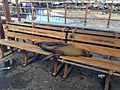
Adult Galápagos sea lion resting on a park bench in Puerto Baquerizo Moreno.

See also
 In Spanish: Provincia de Galápagos para niños

All content from Kiddle encyclopedia articles (including the article images and facts) can be freely used under Attribution-ShareAlike license, unless stated otherwise. Cite this article:
Galápagos Province Facts for Kids. Kiddle Encyclopedia.