Gallo (river) facts for kids
Quick facts for kids Gallo |
|
|---|---|

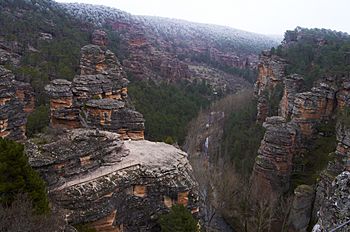
The Gallo as it passes through the Barranco de la Hoz
|
|
| Country | Spain |
| Physical characteristics | |
| Main source | Sierra del Tremedal 40°31′N 1°41′W / 40.517°N 1.683°W |
| River mouth | Tagus 40°47′51″N 2°9′17″W / 40.79750°N 2.15472°W |
| Length | 85 km (53 mi) |
| Basin features | |
| Progression | Tagus→ Atlantic Ocean |
| Basin size | 1,311 km2 (506 sq mi) |
| Tagus Basin | |
The Gallo River is a river located in the middle of the Iberian Peninsula. It is a smaller river that flows into a larger one, the Tagus River. The Gallo River joins the Tagus in its upper part.
The Gallo River is an important part of the natural landscape in this area of Spain. It helps shape the land and supports local plant and animal life.
Where the Gallo River Starts
The Gallo River begins its journey in the Sierra del Tremedal mountains. This area is close to a town called Orihuela del Tremedal. This town is located in the province of Teruel.
The river starts high up in the mountains. From there, it begins to flow downhill.
The River's Journey
The Gallo River is about 85 kilometers (53 miles) long. It flows through different areas as it makes its way to the Tagus River.
When the river reaches the town of Orihuela del Tremedal, it makes a turn. It starts flowing towards the north. After this turn, the Gallo River leaves the province of Teruel. It then enters the province of Guadalajara.
The river continues its path through the landscape of Guadalajara. It passes through various natural areas.
Where the Gallo River Ends
The Gallo River eventually finishes its journey. It flows into the Tagus River. This meeting point is near a place called the San Pedro Bridge.
The Tagus River is one of the longest rivers in the Iberian Peninsula. The Gallo River adds its waters to the Tagus, contributing to its flow.
See also
 In Spanish: Río Gallo para niños

