General Zaragoza, Nuevo León facts for kids
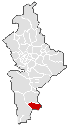
General Zaragoza is a town and a municipality in the state of Nuevo León, Mexico. It's located in the southeastern part of the state. The town sits at an elevation of about 4,520 feet (1,379 meters) above sea level. The whole municipality covers an area of about 508 square miles (1,315 square kilometers). In 2010, about 5,942 people lived here, with most of them living in the main town of Zaragoza. It shares borders with Aramberri to the south and east, Hidalgo, Tamaulipas to the east, and Doctor Arroyo to the west.
General Zaragoza is named after a brave Mexican general, Ignacio Zaragoza. He is famous for leading the Mexican army to victory against the French invaders in the Battle of Puebla on May 5, 1862. This battle is celebrated every year on Cinco de Mayo!
Contents
A Look Back in Time
The very first people to live in the Zaragoza area were groups of nomadic Native Americans. The Spanish explorers called them Negritos, Bozalos, and Janambres.
In 1626, a Franciscan priest named Lorenzo Cantú came to the area. He was from a religious community (a convent) in Charcas. He followed a group of Native Americans to the valley of the Rio Blanco. There, he started a mission called Misión de San Josè del Rio Blanco. This mission was near where Zaragoza is today.
Much later, in 1866, the government officially created the municipality of Villa de General Zaragoza.
Nature and Landscape
Zaragoza is located at the start of the Rio Blanco (White River) valley. This river is part of the larger Soto La Marina River system. Even though the area is semi-arid, meaning it's usually dry, Zaragoza gets a good amount of rain.
Towering Mountains
Some of the tallest mountains in the Sierra Madre Oriental mountain range are found in the Zaragoza municipality.
- Cerro Zaragoza is a mountain that rises to 11,352 feet (3,449 meters). It's about three miles northeast of Zaragoza town.
- Cerro Peña Nevada is even taller at 11,682 feet (3,562 meters). It's about nine miles southwest of Zaragoza town, just across the border in Tamaulipas.
These mountains are covered with beautiful pine and oak forests.
Amazing Waterfalls
Just one to two miles south of Zaragoza town, you can find three amazing waterfalls. They are popular places for tourists to visit.
- One waterfall is 15 meters (49 feet) high.
- Another is 20 meters (65 feet) high.
- The tallest one is 25 meters (82 feet) high.
Weather and Seasons
Zaragoza is lucky to get more rainfall than many other places in semi-arid zones. It receives about 28.7 inches (730 mm) of rain each year. The mountains around Zaragoza get even more rain, and sometimes even snow at higher elevations. For example, Zaragoza Este, which is a mile east of town and higher up, gets about 49.2 inches (1250 mm) of rain every year.
Most of the rain falls during the summer months. The rainy season usually starts in late April and lasts until the end of September. August and September are typically the wettest months in the region around Zaragoza.
Temperatures in Zaragoza are usually mild. However, some days can be very hot. Also, the temperature drops below freezing several times each year, so it can get chilly!
| Climate data for General Zaragoza, Nuevo Leon (1978–2010) | |||||||||||||
|---|---|---|---|---|---|---|---|---|---|---|---|---|---|
| Month | Jan | Feb | Mar | Apr | May | Jun | Jul | Aug | Sep | Oct | Nov | Dec | Year |
| Record high °C (°F) | 37.0 (98.6) |
39.0 (102.2) |
43.0 (109.4) |
43.0 (109.4) |
49.0 (120.2) |
42.0 (107.6) |
42.0 (107.6) |
43.0 (109.4) |
39.0 (102.2) |
42.0 (107.6) |
38.0 (100.4) |
37.0 (98.6) |
49.0 (120.2) |
| Mean daily maximum °C (°F) | 18.5 (65.3) |
21.2 (70.2) |
23.5 (74.3) |
24.1 (75.4) |
27.8 (82.0) |
27.7 (81.9) |
26.7 (80.1) |
27.4 (81.3) |
25.1 (77.2) |
23.5 (74.3) |
22.1 (71.8) |
19.5 (67.1) |
23.9 (75.0) |
| Daily mean °C (°F) | 12.1 (53.8) |
13.9 (57.0) |
16.4 (61.5) |
17.3 (63.1) |
20.3 (68.5) |
20.4 (68.7) |
19.7 (67.5) |
20.1 (68.2) |
18.6 (65.5) |
17.1 (62.8) |
15.3 (59.5) |
13.2 (55.8) |
17.0 (62.6) |
| Mean daily minimum °C (°F) | 5.7 (42.3) |
6.6 (43.9) |
9.2 (48.6) |
10.4 (50.7) |
12.9 (55.2) |
13.1 (55.6) |
12.7 (54.9) |
12.8 (55.0) |
12.1 (53.8) |
10.6 (51.1) |
8.4 (47.1) |
6.9 (44.4) |
10.1 (50.2) |
| Record low °C (°F) | −9 (16) |
−9.0 (15.8) |
−3.0 (26.6) |
0 (32) |
1.0 (33.8) |
4.0 (39.2) |
1.0 (33.8) |
1.0 (33.8) |
0 (32) |
2.0 (35.6) |
−7.0 (19.4) |
−10.0 (14.0) |
−10.0 (14.0) |
| Average precipitation mm (inches) | 20.0 (0.79) |
14.0 (0.55) |
17.0 (0.67) |
47.0 (1.85) |
181.0 (7.13) |
92.0 (3.62) |
58.0 (2.28) |
117.0 (4.61) |
95.0 (3.74) |
18.0 (0.71) |
17.0 (0.67) |
19.0 (0.75) |
730.0 (28.74) |
| Average precipitation days (≥ 0.1 mm) | 2.6 | 1.8 | 2.0 | 4.6 | 8.1 | 8.0 | 6.9 | 8.8 | 8.6 | 4.6 | 2.4 | 3.6 | 62.2 |
| Source 1: Weatherbase: Zargoza, Nuevo León | |||||||||||||
| Source 2: Servicio Meteorológico Nacional (normals) | |||||||||||||
The climate of Zaragoza is classified as Bsk (Koppen) and Bsak (Trewartha). This means it's a dry, semi-arid climate. However, higher up in the mountains near the town, it's cooler and more humid. Some of these higher areas even have a Cw climate, which means they have dry winters and wet summers.


