Soto La Marina River facts for kids
Quick facts for kids Soto La Marina River |
|
|---|---|

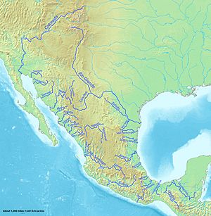
Major rivers of Mexico, with Soto La Marina in the northeast of the country
|
|
| Country | Mexico |
| Physical characteristics | |
| Main source | General Zaragoza, Nuevo León 3,000 m (9,800 ft) |
| River mouth | Gulf of Mexico at La Pesca, Tamaulipas 0 m (0 ft) |
| Length | 416 km (258 mi) |
| Basin features | |
| Basin size | 21,183 km2 (8,179 sq mi) |
The Soto La Marina River is an important river in northeastern Mexico. It's also sometimes called Soto la Marina. This river flows through different parts of Mexico before reaching the Gulf of Mexico.
Contents
River's Journey: From Mountains to Sea
The Soto La Marina River begins high up in the Sierra Madre Oriental mountains. It starts in a place called General Zaragoza, Nuevo León. Here, the river's source is about 3,000 meters (9,800 feet) above sea level. The area is covered with pine and oak forests. You can even find beautiful waterfalls near General Zaragoza.
River's Changing Names
When the river first starts, it's called the Rio Blanco. It flows north at first. Then, near a town called Aramberri, it turns east. When it enters the state of Tamaulipas, its name changes again. It becomes the Purificación River.
The Purificación River then meets another river, the Rio Corona. This happens near the town of Padilla, Tamaulipas. At this spot, a dam creates a large lake called the Vicente Guerrero Reservoir. After the reservoir, the river finally gets its well-known name: the Soto La Marina.
Flowing to the Coast
As the river continues, it reaches the flat coastal plain. It flows past the town of Soto La Marina. Near its end, the river splits into two parts. This forms a delta, which is a landform created by sediment. The river then flows into the Gulf of Mexico.
Boats can travel on the last 50 kilometers (31 miles) of the river. The Soto La Marina is the thirteenth longest river in Mexico.
Surrounding Nature
The lower part of the Soto La Marina River flows through a dry area. This area is called the Tamaulipan mezquital. It has small trees and shrubs that are similar to plants found in southern Texas.
River's Past: A Discovery Story
The Soto La Marina River has an interesting history. A Spanish explorer named Francisco de Garay found it in 1523. Garay was the Governor of Jamaica. He led a group of 600 men. Their goal was to start a new settlement on the Pánuco River.
However, Garay's group landed in the wrong place. They ended up about 160 kilometers (100 miles) north of their target. They landed at the mouth of the Soto La Marina River. Garay called it the River of Palms (Rio de las Palmas).
He sent a small boat up the river. It went about 40 kilometers (25 miles) upstream. This was probably near where the city of Soto la Marina is today. The explorers saw about 40 Native American camps along the river. This showed that many people lived there. These people used canoes to travel on the river. At first, they were friendly. But later, they became unfriendly.
Garay soon realized this was not the Pánuco River. So, he ordered his men to march south by land to find the Pánuco.
Some people used to think the Rio de las Palmas was the Rio Grande. But most experts now agree it was the Soto La Marina River.
See also
 In Spanish: Río Soto La Marina para niños
- List of longest rivers of Mexico
- List of rivers of Mexico
 | Leon Lynch |
 | Milton P. Webster |
 | Ferdinand Smith |


