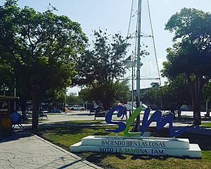
Soto la Marina, Tamaulipas facts for kids
Soto la Marina is a town in Tamaulipas, a state in Mexico. It is located on the banks of the Soto la Marina river. This river flows into the ocean near a small port called La Pesca. The town is also downriver from Ciudad Victoria, which is the capital city of Tamaulipas.
In 2010, Soto la Marina was directly hit by a big storm called Hurricane Alex. The town is about 180 miles south of Brownsville, Texas, and you can reach it by car in about three hours.
The area around Soto la Marina includes parts of a mountain range known as the Sierra de Tamaulipas.
Contents
What is the Climate Like in Soto la Marina?
Soto la Marina has a climate that is mostly semi-dry. This means it doesn't get a lot of rain. However, it's also quite close to a humid subtropical and a tropical savanna climate.
Winter Weather in Soto la Marina
Winters in Soto la Marina are short and mild. The average highest temperature in January, the coldest month, is about 24 degrees Celsius (75 degrees Fahrenheit). The lowest average temperature is around 10 degrees Celsius (50 degrees Fahrenheit). Even in winter, temperatures can sometimes go above 40 degrees Celsius (104 degrees Fahrenheit)! It doesn't rain much in winter, but it can often be foggy and cloudy. It almost never freezes here.
Summer Weather in Soto la Marina
Summers are long, hot, and humid. June is usually the warmest month, with an average temperature of about 29.6 degrees Celsius (85.3 degrees Fahrenheit). It's much sunnier during the summer. You can expect about 13 to 14 clear days each month. This is more than the 8 to 10 clear days seen from December to February.
Rainfall and Extreme Temperatures
The town gets about 699.5 millimeters (27.5 inches) of rain each year. Most of the rain falls between June and October. The hottest temperature ever recorded was 48.3 degrees Celsius (118.9 degrees Fahrenheit) on April 29, 1953. The coldest temperature ever recorded was -7.7 degrees Celsius (18.1 degrees Fahrenheit) on December 12, 1957.
| Climate data for Soto La Marina (1951–2010) | |||||||||||||
|---|---|---|---|---|---|---|---|---|---|---|---|---|---|
| Month | Jan | Feb | Mar | Apr | May | Jun | Jul | Aug | Sep | Oct | Nov | Dec | Year |
| Record high °C (°F) | 37.5 (99.5) |
40.5 (104.9) |
43.0 (109.4) |
48.0 (118.4) |
45.4 (113.7) |
45.7 (114.3) |
42.0 (107.6) |
43.5 (110.3) |
42.6 (108.7) |
38.5 (101.3) |
39.0 (102.2) |
37.0 (98.6) |
48.0 (118.4) |
| Mean daily maximum °C (°F) | 24.3 (75.7) |
27.1 (80.8) |
30.1 (86.2) |
32.7 (90.9) |
35.2 (95.4) |
36.2 (97.2) |
36.0 (96.8) |
36.7 (98.1) |
34.3 (93.7) |
31.8 (89.2) |
28.2 (82.8) |
24.6 (76.3) |
31.4 (88.5) |
| Daily mean °C (°F) | 17.3 (63.1) |
19.6 (67.3) |
22.4 (72.3) |
25.3 (77.5) |
28.3 (82.9) |
29.6 (85.3) |
29.1 (84.4) |
29.5 (85.1) |
27.9 (82.2) |
24.9 (76.8) |
21.4 (70.5) |
17.9 (64.2) |
24.4 (75.9) |
| Mean daily minimum °C (°F) | 10.3 (50.5) |
12.1 (53.8) |
14.8 (58.6) |
18.0 (64.4) |
21.5 (70.7) |
23.0 (73.4) |
22.2 (72.0) |
22.2 (72.0) |
21.5 (70.7) |
18.0 (64.4) |
14.6 (58.3) |
11.3 (52.3) |
17.5 (63.5) |
| Record low °C (°F) | −2.5 (27.5) |
1.0 (33.8) |
−0.5 (31.1) |
2.5 (36.5) |
12.0 (53.6) |
15.5 (59.9) |
18.5 (65.3) |
14.5 (58.1) |
11.0 (51.8) |
3.2 (37.8) |
−1.5 (29.3) |
−6.5 (20.3) |
−6.5 (20.3) |
| Average precipitation mm (inches) | 41.6 (1.64) |
11.4 (0.45) |
16.9 (0.67) |
36.7 (1.44) |
38.8 (1.53) |
89.9 (3.54) |
72.3 (2.85) |
97.8 (3.85) |
155.8 (6.13) |
76.4 (3.01) |
29.1 (1.15) |
32.8 (1.29) |
699.5 (27.54) |
| Average precipitation days (≥ 0.1 mm) | 4.6 | 3.0 | 3.0 | 3.8 | 4.2 | 6.4 | 5.9 | 5.6 | 7.8 | 5.3 | 4.0 | 4.2 | 57.8 |
| Average relative humidity (%) | 67 | 65 | 62 | 65 | 64 | 64 | 65 | 64 | 67 | 67 | 66 | 69 | 65 |
| Mean monthly sunshine hours | 160 | 173 | 208 | 220 | 257 | 252 | 302 | 266 | 204 | 214 | 152 | 162 | 2,570 |
| Source 1: Servicio Meteorológico Nacional (humidity 1981–2000) | |||||||||||||
| Source 2: Deutscher Wetterdienst (sun, 1961–1990) | |||||||||||||
See Also
 In Spanish: Soto la Marina para niños
 | Emma Amos |
 | Edward Mitchell Bannister |
 | Larry D. Alexander |
 | Ernie Barnes |


