
Sierra de Tamaulipas facts for kids
Quick facts for kids Sierra de Tamaulipas |
|
|---|---|

Location in Mexico
|
|
| Geography | |
| Location | Tamaulipas, Mexico |
| Range coordinates | 23°15′N 98°24′W / 23.250°N 98.400°W |
The Sierra de Tamaulipas is a special mountain range in Tamaulipas, Mexico. It's like an island of mountains, separate from others. Its highest peak is about 1,260 m (4,130 ft) (4,134 feet) tall. Not many people live here, and most of them are farmers.
Up high, you'll find forests with oak and pine trees. Down lower, the land is drier with thorny bushes. This area was once home to ancient farming people from Mesoamerica. They lived here, making it the northernmost place where farming was done in eastern Mexico.
On December 5, 2016, the Mexican government made the Sierra de Tamaulipas a "Protected Natural Area." This means it's a special place that is now protected. The protected area covers a large space, about 38,285 hectares (94,600 acres) in its main part. There's also a bigger surrounding area of 269,992 hectares (667,160 acres) that helps protect it.
Contents
Exploring the Mountains and Land

The Sierra de Tamaulipas stretches about 110 kilometres (68 mi) (68 miles) from north to south. It is about 64 kilometres (40 mi) (40 miles) wide at its widest part. The whole area covers about 3,339 square kilometres (1,289 sq mi). The land here goes from about 300 metres (980 ft) (984 feet) up to 1,260 metres (4,130 ft) (4,134 feet) high.
This mountain range is like a "Sky island." This means it's a high, cool, and wet area surrounded by lower, drier land. The land around the Sierra is mostly covered in thorny forests. But inside the Sierra, because it gets more rain and is cooler, you find different kinds of plants.
At heights of 300 to 700 metres (980 to 2,300 ft), there are tropical forests. These forests have tall trees, about 7.5 metres (25 ft) (25 feet) high. In drier spots between 600 and 900 metres (2,000 and 3,000 ft), you'll see low bushes and grassy areas. Higher up, above 800 metres (2,600 ft), there are pine and oak forests. These are like a cool, green island in the warmer region. If these areas are left alone, they can be very lush with many ferns.
Southeast of the Sierra, in a town called Aldama, Tamaulipas, there's a special area made of limestone. Here, you can find many caves and cenotes. Cenotes are deep, water-filled sinkholes. One of these is Zacatón, which is the deepest sinkhole in the world. It goes down about 339 metres (1,112 ft) (1,112 feet).
No big roads or rivers cut through the Sierra. There are no cities or towns inside it either. The people who live here mostly live in the countryside. Many small, clear streams flow from the highest parts of the Sierra in all directions.
Weather in the Sierra
The amount of rain in the Sierra de Tamaulipas changes depending on how high you are. Lower areas get about 710 millimetres (28 in) (28 inches) of rain. Higher areas get more than 1,000 millimetres (39 in) (39 inches). Most of the rain falls in the summer, from May to October. However, winters here are not as dry as in many other parts of Mexico.
It rarely freezes at lower elevations. But in the cooler forests higher up, it freezes more often. The weather in a small village called Santa Maria de los Nogales is a good example of the climate in the higher parts of the Sierra.
The climate here is called sub-tropical. This means it has hot summers and dry, warm winters.
| Climate data for Santa Maria de los Nogales, Tamaulipas. 23 12 29N, 98 21 30W, Elevation: 3,041 ft (927 m) (1950-2010) | |||||||||||||
|---|---|---|---|---|---|---|---|---|---|---|---|---|---|
| Month | Jan | Feb | Mar | Apr | May | Jun | Jul | Aug | Sep | Oct | Nov | Dec | Year |
| Record high °C (°F) | 36.0 (96.8) |
35.0 (95.0) |
40.0 (104.0) |
41.0 (105.8) |
43.5 (110.3) |
41.0 (105.8) |
39.0 (102.2) |
37.0 (98.6) |
37.0 (98.6) |
32.5 (90.5) |
36.0 (96.8) |
33.5 (92.3) |
43.5 (110.3) |
| Mean daily maximum °C (°F) | 19.7 (67.5) |
21.4 (70.5) |
25.1 (77.2) |
27.3 (81.1) |
28.8 (83.8) |
28.6 (83.5) |
27.9 (82.2) |
27.8 (82.0) |
26.7 (80.1) |
24.6 (76.3) |
22.4 (72.3) |
20.0 (68.0) |
25.0 (77.0) |
| Daily mean °C (°F) | 13.8 (56.8) |
14.8 (58.6) |
17.9 (64.2) |
20.1 (68.2) |
22.3 (72.1) |
22.8 (73.0) |
22.6 (72.7) |
22.2 (72.0) |
21.3 (70.3) |
19.0 (66.2) |
16.9 (62.4) |
14.5 (58.1) |
19.0 (66.2) |
| Mean daily minimum °C (°F) | 7.8 (46.0) |
8.3 (46.9) |
10.8 (51.4) |
13.0 (55.4) |
15.8 (60.4) |
16.9 (62.4) |
17.3 (63.1) |
16.6 (61.9) |
16.0 (60.8) |
13.5 (56.3) |
11.3 (52.3) |
9.0 (48.2) |
13.0 (55.4) |
| Record low °C (°F) | −5 (23) |
−5.5 (22.1) |
−2.0 (28.4) |
1.5 (34.7) |
5.5 (41.9) |
6.0 (42.8) |
7.5 (45.5) |
7.5 (45.5) |
6.0 (42.8) |
0.0 (32.0) |
−5.0 (23.0) |
−9.0 (15.8) |
−9.0 (15.8) |
| Average precipitation mm (inches) | 28.0 (1.10) |
16.0 (0.63) |
20.0 (0.79) |
37.0 (1.46) |
79.0 (3.11) |
135.0 (5.31) |
140.0 (5.51) |
158.0 (6.22) |
199.0 (7.83) |
87.0 (3.43) |
27.0 (1.06) |
39.0 (1.54) |
965.0 (37.99) |
| Average precipitation days (≥ 0.1 mm) | 5.8 | 4.1 | 3.2 | 4.4 | 7.2 | 8.8 | 9.4 | 11.1 | 11.7 | 7.4 | 5.9 | 6.2 | 85.2 |
| Source: Weatherbase: Santa Maria de los Nogales, Tamaulipas. | |||||||||||||
Ancient Cultures and History
The Sierra de Tamaulipas likely was the northernmost place in eastern Mexico where people grew maize (corn) long ago. This was because it got more rain than the dry lands around it. North of here, in the dry brushlands, lived nomadic people who hunted and gathered food. They were called Coahuiltecans.
An archaeologist named Richard MacNeish found proof that corn was grown in the Sierra de Tamaulipas as early as 2,500 BC. This shows that people started to settle down and farm instead of always moving around.
From 300 to 550 AD, several villages in the Sierra de Tamaulipas were the northern edge of the Huastec culture. The Huastec were a group of people from Mesoamerica. Their villages had public squares and small pyramids. This suggests they had an organized government, possibly led by religious leaders.
The ancient ruin of El Sabinito is about 20 km (13 miles) southwest of the city of Soto la Marina. It's at the northern edge of the Sierra. El Sabinito might have had 600 houses and about 1,500 people when it was at its biggest. It was left empty around 1300 AD. This might have happened because the climate changed, making farming harder. Experts think the people might have gone back to hunting and gathering food.
The first European to visit the coast near the Sierra was Francisco de Garay in 1523. Garay saw that people were growing corn up to a certain point, near the Tropic of Cancer. North of there, he found hunter-gatherers. Garay's men said these people were many and were fierce along the lower parts of the Soto La Marina River.
Images for kids
-
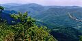
Sierra de Tamaulipas, Municipality of Aldama, Tamaulipas, Mexico
-
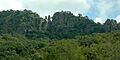
View of karstic formations in the Sierra de Tamaulipas, Municipality of Llera, Tamaulipas, Mexico.


See also
 In Spanish: Sierra de Tamaulipas para niños
