Gerrans Bay to Camels Cove facts for kids
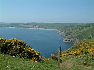
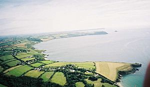
Gerrans Bay to Camels Cove is a special coastal area in south Cornwall, England. It's known as a Site of Special Scientific Interest (SSSI). This means it's a very important place for both its amazing plants and animals, and its interesting rocks and landforms.
Contents
Exploring Gerrans Bay to Camels Cove
This important coastal area covers about 139.5 hectares (that's like 345 acres!). It was first recognized as special in 1951. You can find it on the south coast of Cornwall, right next to the English Channel. It's about 6 miles (10 km) southeast of the city of Truro.
Where is Gerrans Bay to Camels Cove?
The site begins at a spot called Creek Stephen Point in the west. It then follows the beautiful coastline of Gerrans Bay all the way to Nare Head. From there, it continues to Manare Point, which is close to the village of Portloe in the east. There's also a small island called Gull Rock included in this special area, just off the coast.
Walking the Coast Path
A famous walking route, the South West Coast Path, goes right through this SSSI. This means you can explore much of its stunning scenery on foot. Most of the coastline in this area is looked after by the National Trust. They work to protect special places for everyone to enjoy.
A Part of Cornwall's Beauty
This entire area is also part of the Cornwall Area of Outstanding Natural Beauty (AONB). This is another way to show how important and beautiful this part of Cornwall truly is.
History of the Protected Area
The Gerrans Bay to Camels Cove SSSI you see today is actually a combination of two older protected areas. These were once known as the Gerrans Bay to Nare Head SSSI and the Camels Cove SSSI. They were joined together to create the larger, more comprehensive site we have now.


