Girdletree, Maryland facts for kids
Quick facts for kids
Girdletree, Maryland
|
|
|---|---|

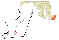
Location of Girdletree, Maryland
|
|
| Country | United States |
| State | Maryland |
| County | Worcester |
| Area | |
| • Total | 0.68 sq mi (1.77 km2) |
| • Land | 0.68 sq mi (1.77 km2) |
| • Water | 0.00 sq mi (0.00 km2) |
| Elevation | 36 ft (11 m) |
| Population
(2020)
|
|
| • Total | 141 |
| • Density | 206.44/sq mi (79.76/km2) |
| Time zone | UTC−5 (Eastern (EST)) |
| • Summer (DST) | UTC−4 (EDT) |
| ZIP code |
21829
|
| Area code(s) | 410, 443 |
| FIPS code | 24-32250 |
| GNIS feature ID | 0590303 |
Girdletree is a small community located in Worcester County, Maryland, in the United States. It's known as a census-designated place, which means it's an area with a name but not an official town government. In 2010, about 149 people lived here. Girdletree is also part of the larger Salisbury area, which includes parts of Maryland and Delaware.
Where is Girdletree?
Girdletree is located in the eastern part of Maryland. You can find it at these coordinates: 38°5′40″N 75°24′0″W / 38.09444°N 75.40000°W.
Size of the Area
According to the United States Census Bureau, Girdletree covers a total area of about 0.7 square miles (1.77 square kilometers). All of this area is land, with no large bodies of water inside its borders.
Who Lives in Girdletree?
| Historical population | |||
|---|---|---|---|
| Census | Pop. | %± | |
| 2020 | 141 | — | |
| U.S. Decennial Census | |||
In the year 2000, there were 117 people living in Girdletree. These people lived in 48 different homes, and 32 of those were families.
Population Details
The population density was about 213 people per square mile. This means that for every square mile of land, there were roughly 213 people. There were also 56 housing units, which are places where people can live.
In 2000, about 26.5% of the people were under 18 years old. About 15.4% were 65 years old or older. The average age of people in Girdletree was 38 years.
See also
 In Spanish: Girdletree para niños
 | William L. Dawson |
 | W. E. B. Du Bois |
 | Harry Belafonte |

