Glade Creek (New River tributary) facts for kids
Quick facts for kids Glade Creek |
|
|---|---|

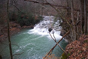
Waterfalls along Glade Creek
|
|
| Country | United States |
| State | West Virginia |
| Counties | Raleigh |
| Physical characteristics | |
| Main source | Flat Top Mountain Raleigh County, WV 3,271 ft (997 m) 37°35′25″N 81°05′41″W / 37.59028°N 81.09472°W |
| River mouth | New River Raleigh County, WV 1,207 ft (368 m) 37°49′47″N 81°00′46″W / 37.82972°N 81.01278°W |
Glade Creek is an important stream located in Raleigh County, West Virginia. It flows into the New River. This creek runs through the biggest side valley of the New River in the famous New River Gorge National River area.
Contents
Exploring the Glade Creek Canyon
Just north of the Glade Creek Reservoir, the creek starts to carve out a deep canyon. This canyon can be about 200 feet (61 m) deep at its beginning. As it gets closer to the New River, near a town called Prince, the canyon becomes much deeper, reaching over 1,200 feet (370 m)!
Hiking Trails in the Canyon
A long time ago, a railroad track ran through the lower part of the Glade Creek canyon. Today, this old railroad path has been turned into a fun hiking trail. The New River Gorge National River takes care of this trail, making it a great place for people to explore the beautiful canyon.
The Phil G. McDonald Bridge: A Giant Crossing
About 5 miles (8.0 km) from where Glade Creek meets the New River, you'll find a huge bridge crossing over it. This is the Phil G. McDonald Bridge, also known as the Glade Creek Bridge. It's part of Interstate 64, a major highway.
How Big is the Bridge?
The Phil G. McDonald Bridge is 2,179-foot (664 m) long. It stands incredibly high above the creek, towering 700 feet (210 m) over the water! This makes it the highest Interstate bridge in the entire United States. Imagine looking down from that height!
 | Aurelia Browder |
 | Nannie Helen Burroughs |
 | Michelle Alexander |

