Glen Osborne, Pennsylvania facts for kids
Quick facts for kids
Glen Osborne, Pennsylvania
|
||
|---|---|---|
|
Borough
|
||

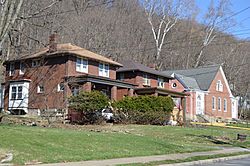
Neighborhood on Beaver Street
|
||
|
||

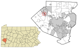
Location in Allegheny County and the U.S. state of Pennsylvania.
|
||
| Country | United States | |
| State | Pennsylvania | |
| County | Allegheny | |
| Incorporated | 1883, as Osborne | |
| Renamed | 2008, as Glen Osborne | |
| Area | ||
| • Total | 0.56 sq mi (1.45 km2) | |
| • Land | 0.43 sq mi (1.11 km2) | |
| • Water | 0.13 sq mi (0.34 km2) | |
| Population
(2020)
|
||
| • Total | 590 | |
| • Density | 1,372.09/sq mi (529.53/km2) | |
| Time zone | UTC-5 (Eastern (EST)) | |
| • Summer (DST) | UTC-4 (EDT) | |
| FIPS code | 42-29732 | |
| GNIS | 1214815 | |
| Website | Borough website | |
Glen Osborne is a small town, also called a borough, in Allegheny County, Pennsylvania. It is located right next to the Ohio River. In 2020, about 590 people lived there. Glen Osborne is a quiet, residential area that is part of the larger Pittsburgh metropolitan area.
Contents
History of Glen Osborne
The land where Glen Osborne is today was first explored after the American Revolutionary War. Early settlers like Henry Pratt arrived in 1786. The area became known as "Glen Osborne." The word "glen" is a Scottish term for a valley, and "Osborne" came from a local landowner named Frank Osborne.
In 1851, a railroad called the Pittsburgh, Fort Wayne and Chicago Railroad was built through the area. A train station opened and was named "Osborne." This helped avoid confusion with other stations. In 1883, local people asked for their community to become an official borough. It was then named the borough of Osborne.
In 2008, the town's leaders, including Mayor William P. Boswell, asked the state to change the borough's name. They wanted to officially call it Glen Osborne, which was the name people had been using for over a hundred years. A judge agreed to the name change on May 21, 2008. Soon after, road signs and other town materials were updated with the new name.
Geography and Nature
Glen Osborne is located at 40°31′51″N 80°10′9″W / 40.53083°N 80.16917°W. It covers about 0.6 square miles (1.6 square kilometers). Most of this area is land, but about 0.1 square miles (0.3 square kilometers) is water. The borough sits on the north side of the Ohio River.
One special place in Glen Osborne is the Mary Roberts Rinehart Nature Park. This park has trails that go through forests and along streams. You can also see beautiful gardens there that attract pollinators like bees and butterflies.
Neighboring Communities
Glen Osborne shares its land borders with three other communities:
- Sewickley is to the northwest.
- Aleppo Township is to the north, northeast, and east.
- Haysville is to the southeast.
Across the Ohio River, Glen Osborne is close to:
- Coraopolis to the south and southeast.
- Moon Township to the southwest.
Population Information
| Historical population | |||
|---|---|---|---|
| Census | Pop. | %± | |
| 1890 | 221 | — | |
| 1900 | 362 | 63.8% | |
| 1910 | 425 | 17.4% | |
| 1920 | 358 | −15.8% | |
| 1930 | 506 | 41.3% | |
| 1940 | 529 | 4.5% | |
| 1950 | 496 | −6.2% | |
| 1960 | 609 | 22.8% | |
| 1970 | 579 | −4.9% | |
| 1980 | 529 | −8.6% | |
| 1990 | 565 | 6.8% | |
| 2000 | 566 | 0.2% | |
| 2010 | 547 | −3.4% | |
| 2020 | 590 | 7.9% | |
| Sources: | |||
In 2000, there were 566 people living in Glen Osborne. Most of the people were White (98.06%). A small number were African American (1.59%) or from other backgrounds.
The average age of people in Glen Osborne in 2000 was 44 years old. About 27.7% of the population was under 18 years old.
The median income for a household in 2000 was $64,375. This means that half of the households earned more than this amount, and half earned less.
See also
 In Spanish: Glen Osborne para niños


