Glenwood Plantation, Maine facts for kids
Quick facts for kids
Glenwood Plantation, Maine
|
|
|---|---|
|
Plantation
|
|

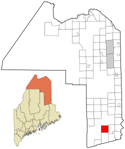
Location of Glenwood Plantation, Maine
|
|
| Country | United States |
| State | Maine |
| County | Aroostook |
| Area | |
| • Total | 39.5 sq mi (102.4 km2) |
| • Land | 38.1 sq mi (98.8 km2) |
| • Water | 1.4 sq mi (3.6 km2) |
| Elevation | 561 ft (171 m) |
| Population
(2020)
|
|
| • Total | 5 |
| • Density | 0.127/sq mi (0.049/km2) |
| Time zone | UTC-5 (Eastern (EST)) |
| • Summer (DST) | UTC-4 (EDT) |
| ZIP code |
04497
|
| Area code(s) | 207 |
| FIPS code | 23-27855 |
| GNIS feature ID | 0582492 |
Glenwood Plantation is a special type of community called a plantation. It is located in Aroostook County, which is in the state of Maine, United States.
In 2020, a count of all people living there, called a census, showed that only 5 people lived in Glenwood Plantation. This makes it a very small and quiet place.
Where is Glenwood Plantation?
Glenwood Plantation is in the northeastern part of the United States. It is part of Maine, a state known for its beautiful forests and coastline.
Land and Water
The area of Glenwood Plantation is about 102.4 square kilometers (or 39.5 square miles). Most of this area is land. About 98.8 square kilometers (38.1 square miles) is land, and 3.6 square kilometers (1.4 square miles) is water. This means there are likely some small lakes, rivers, or streams within its borders.
How Many People Live Here?
The number of people living in Glenwood Plantation has changed a lot over the years. Here's a look at how the population has grown and shrunk:
- In 1870, there were 185 people.
- By 1900, the population had gone down to 178.
- It kept getting smaller, reaching 87 people in 1920.
- In 1950, only 53 people lived there.
- By 1970, the number was just 9.
- In 2010, it reached its lowest point with only 3 people.
- However, by the 2020 census, the population slightly increased to 5 people.
This shows that Glenwood Plantation has always been a very small community.
See also
 In Spanish: Glenwood Plantation para niños
 | DeHart Hubbard |
 | Wilma Rudolph |
 | Jesse Owens |
 | Jackie Joyner-Kersee |
 | Major Taylor |

