Goldsboro, Maryland facts for kids
Quick facts for kids
Goldsboro, Maryland
|
||
|---|---|---|

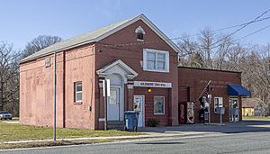
The Goldsboro town hall and post office in 2016
|
||
|
||

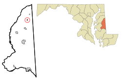
Location of Goldsboro, Maryland
|
||
| Country | ||
| State | ||
| County | ||
| Incorporated | 1906 | |
| Area | ||
| • Total | 0.79 sq mi (2.05 km2) | |
| • Land | 0.78 sq mi (2.02 km2) | |
| • Water | 0.01 sq mi (0.03 km2) | |
| Elevation | 56 ft (17 m) | |
| Population
(2020)
|
||
| • Total | 211 | |
| • Density | 269.82/sq mi (104.24/km2) | |
| Time zone | UTC-5 (Eastern (EST)) | |
| • Summer (DST) | UTC-4 (EDT) | |
| ZIP code |
21636
|
|
| Area code(s) | 410 | |
| FIPS code | 24-33950 | |
| GNIS feature ID | 0590343 | |
Goldsboro is a small town located in Caroline County, Maryland, in the United States. In 2020, about 211 people lived there. The town's ZIP code is 21636.
Goldsboro was first known as Oldtown. It got its current name in 1870. The name honors the important Goldsborough family who owned a lot of land in the area. A historic building called Castle Hall was added to the National Register of Historic Places in 1975. This means it's a special place worth protecting.
Contents
Town Location and Size
Goldsboro is located at a specific point on the map: 39 degrees, 2 minutes, 8 seconds North and 75 degrees, 47 minutes, 14 seconds West.
The United States Census Bureau says the town covers a total area of about 0.79 square miles (2.05 square kilometers). Most of this area, about 0.78 square miles (2.02 square kilometers), is land. Only a tiny part, about 0.01 square miles (0.03 square kilometers), is water.
Getting Around Goldsboro
The main way to travel to and from Goldsboro is by road. Three state highways serve the town, helping people get where they need to go:
- Maryland Route 313 comes into town from the south and then turns west.
- Maryland Route 311 heads north from MD 313.
- Maryland Route 287 goes east from MD 313 in Goldsboro.
How Many People Live Here?
The number of people living in Goldsboro has changed over the years. Here's a quick look at the population counts from different years:
| Historical population | |||
|---|---|---|---|
| Census | Pop. | %± | |
| 1910 | 201 | — | |
| 1920 | 224 | 11.4% | |
| 1930 | 211 | −5.8% | |
| 1940 | 197 | −6.6% | |
| 1950 | 198 | 0.5% | |
| 1960 | 204 | 3.0% | |
| 1970 | 231 | 13.2% | |
| 1980 | 188 | −18.6% | |
| 1990 | 185 | −1.6% | |
| 2000 | 216 | 16.8% | |
| 2010 | 246 | 13.9% | |
| 2020 | 211 | −14.2% | |
| U.S. Decennial Census | |||
Goldsboro Population in 2010
In 2010, the town had 246 people living in 87 households. About 69 of these households were families. The town had about 332 people per square mile. There were 97 housing units in total.
Most of the people in Goldsboro were White (87.0%). A smaller number were African American (4.9%) or Native American (0.4%). About 7.3% were from other races, and 0.4% were from two or more races. About 8.1% of the population identified as Hispanic or Latino.
Many households (43.7%) had children under 18 living with them. More than half (54.0%) were married couples. Some households (18.4%) had a female head without a husband, and a few (6.9%) had a male head without a wife. About 19.5% of households were single individuals.
The average age of people in Goldsboro in 2010 was 34 years old. About 30.5% of residents were under 18. About 14.6% were 65 years old or older. The town had slightly more females (53.3%) than males (46.7%).
See also
 In Spanish: Goldsboro (Maryland) para niños
 | Madam C. J. Walker |
 | Janet Emerson Bashen |
 | Annie Turnbo Malone |
 | Maggie L. Walker |


