
Goldsworthy, Western Australia facts for kids
Quick facts for kids GoldsworthyWestern Australia |
|
|---|---|

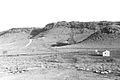
1964 photograph showing iron ore outcrops on the top of Mount Goldsworthy before mining commenced
|
|

Goldsworthy
Location in Western Australia
|
|
| Established | 1965 |
| Elevation | 46 m (151 ft) |
| Location |
|
| LGA(s) | Shire of East Pilbara |
| State electorate(s) | Pilbara |
| Federal Division(s) | Durack |
Goldsworthy is a former mining town in Western Australia. It is located east of Port Hedland in the Shire of East Pilbara. Goldsworthy was named after a nearby mountain, Mount Goldsworthy. It was the very first iron ore mine in the Pilbara region of Western Australia.
Contents
Discovering Iron Ore at Goldsworthy
Early Explorations
People knew about iron ore in the Goldsworthy area for a long time. An explorer named Francis Thomas Gregory first reported seeing iron ore there in 1861. Later, in 1890, a government Geologist named H.P. Woodward confirmed this discovery.
In 1919, another government geologist, Andrew Gibb Maitland, also confirmed the iron ore deposits. However, at that time, it was too expensive to mine the ore and sell it.
Estimating the Ore and Export Ban
In 1938, geologists Kevin Finucane and Robert Telford studied Mount Goldsworthy. They estimated there were over 6 million tons of iron ore. This ore was very rich, with about 65.66% iron.
Before Second World War began, the Australian government stopped the export of iron ore. This was because iron was considered a very important material for making weapons and other wartime supplies. This ban meant that mining the ore was not allowed.
Frank Thompson Jr., who owned a nearby cattle station called Pardoo Station, had mining leases in the area. But because of the export ban, he let his leases expire.
Lifting the Ban and New Opportunities
The export ban was finally lifted in December 1960. This opened up a big chance for companies to start mining iron ore again. The government planned to give special permission, called an export licence, to mine and sell the ore from Goldsworthy.
An Indigenous group called the Pindan Group was also very interested in mining. Their chairman, Ernie Mitchell, asked the government to give his group an export licence. He argued that his group had the skills and workforce needed for the project. They also knew the local area very well.
Building the Mine and Town
Forming a Mining Group
In February 1962, three big international mining companies joined together. They were Consolidated Goldfields (Aust) Pty Ltd from Britain, Cyprus Mines Corporation from Los Angeles, and Utah Construction & Mining Company from San Francisco. They formed a group called Mount Goldsworthy Mining Associates (GML).
In early 1963, this group was given the special export licence. This meant they could ship 4 million tons of iron ore each year. They planned to build a new port at Finucane Island in Port Hedland, which is about 100 kilometers west of Goldsworthy.
First Shipments of Ore
The mining group signed a deal with Japanese steel companies in February 1965. The deal said that the first shipment of ore had to be made within 15 months.
Work on building the port and the new town of Goldsworthy started in February 1965. The first train carrying iron ore arrived at Finucane Island on December 1, 1965. The very first ship, called Harvey S. Mudd, was loaded with 24,900 tons of ore on June 26, 1966.
Life in Goldsworthy
At its busiest time, about 700 people lived in Goldsworthy in 200 houses. The town was hit by Cyclone Amy in 1980, but it was rebuilt.
The End of Goldsworthy
Mine Closure and Town Abandonment
The mine at Goldsworthy stopped operating on December 22, 1982. Mining operations at a nearby place called Shay Gap also ended in 1993.
The town of Goldsworthy itself was completely abandoned in 1992. When the town closed, all the buildings were removed. Any plants that were not native to the area were burned. Even the roads were torn up. This was done because the government wanted the land to return to its natural state. They wanted to avoid creating a ghost town.
What Remains Today
Today, there is very little left at the site to show that a town ever existed. The large pit where the mining happened is still there, but it is now filled with water. A railway line that goes to other mines passes nearby. There is also a solar-powered radio repeater site that helps with communication for the railway. If you look from an airplane, you can still see the outlines of where the streets used to be.
Climate
| Climate data for Goldsworthy | |||||||||||||
|---|---|---|---|---|---|---|---|---|---|---|---|---|---|
| Month | Jan | Feb | Mar | Apr | May | Jun | Jul | Aug | Sep | Oct | Nov | Dec | Year |
| Record high °C (°F) | 48.5 (119.3) |
47.8 (118.0) |
46.0 (114.8) |
43.1 (109.6) |
39.9 (103.8) |
34.3 (93.7) |
35.6 (96.1) |
37.7 (99.9) |
42.1 (107.8) |
44.4 (111.9) |
48.0 (118.4) |
47.1 (116.8) |
48.5 (119.3) |
| Mean daily maximum °C (°F) | 39.6 (103.3) |
38.8 (101.8) |
38.7 (101.7) |
36.5 (97.7) |
31.6 (88.9) |
28.3 (82.9) |
28.0 (82.4) |
30.5 (86.9) |
34.3 (93.7) |
37.6 (99.7) |
39.5 (103.1) |
40.4 (104.7) |
35.3 (95.5) |
| Mean daily minimum °C (°F) | 26.5 (79.7) |
26.3 (79.3) |
26.1 (79.0) |
23.8 (74.8) |
19.7 (67.5) |
16.6 (61.9) |
15.0 (59.0) |
16.5 (61.7) |
19.0 (66.2) |
21.5 (70.7) |
23.7 (74.7) |
25.3 (77.5) |
21.7 (71.1) |
| Record low °C (°F) | 20.5 (68.9) |
19.1 (66.4) |
18.9 (66.0) |
16.1 (61.0) |
12.2 (54.0) |
8.7 (47.7) |
6.9 (44.4) |
9.2 (48.6) |
12.2 (54.0) |
15.1 (59.2) |
16.3 (61.3) |
17.5 (63.5) |
6.9 (44.4) |
| Average precipitation mm (inches) | 67.6 (2.66) |
93.9 (3.70) |
57.9 (2.28) |
15.0 (0.59) |
23.1 (0.91) |
19.0 (0.75) |
9.8 (0.39) |
3.9 (0.15) |
1.3 (0.05) |
2.5 (0.10) |
2.3 (0.09) |
28.0 (1.10) |
329.7 (12.98) |
| Average precipitation days | 6.3 | 8.0 | 4.3 | 1.5 | 2.1 | 1.9 | 1.0 | 0.4 | 0.2 | 0.2 | 0.3 | 2.5 | 25.7 |
| Average relative humidity (%) | 35 | 37 | 32 | 24 | 27 | 27 | 22 | 21 | 17 | 19 | 21 | 27 | 26 |
Images for kids
-
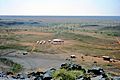
Mount Goldsworthy from the GML exploration camp – Christmas 1963
-
Original exploration camp. The "dongas" to accommodate extra staff during the "proving of reserves stage" were added in 1964.
-
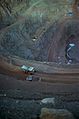
The pit looking eastwards in 1978
-
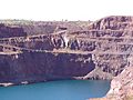
The abandoned pit at Mount Goldsworthy in 2008


