Gorman, North Carolina facts for kids
Quick facts for kids
Gorman, North Carolina
|
|
|---|---|

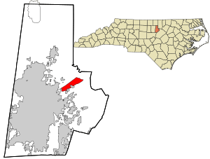
Location in Durham County and the state of North Carolina
|
|
| Country | United States |
| State | North Carolina |
| County | Durham |
| Area | |
| • Total | 2.96 sq mi (7.66 km2) |
| • Land | 2.90 sq mi (7.51 km2) |
| • Water | 0.06 sq mi (0.14 km2) |
| Elevation | 328 ft (100 m) |
| Population
(2020)
|
|
| • Total | 1,104 |
| • Density | 380.56/sq mi (146.92/km2) |
| Time zone | UTC-5 (Eastern (EST)) |
| • Summer (DST) | UTC-4 (EDT) |
| ZIP code |
27704
|
| Area code(s) | 919 and 984 |
| FIPS code | 37-27120 |
| GNIS feature ID | 2402539 |
Gorman is a small community in Durham County, North Carolina, United States. It's known as a census-designated place (CDP). This means it's an area that looks like a town but isn't officially governed as one. In 2010, about 1,011 people lived there. By 2020, the population had grown to 1,104 people.
Contents
Where is Gorman Located?
Gorman is in the eastern part of Durham County. It sits between the city of Durham to its southwest and Falls Lake to its northeast. Falls Lake is a large lake on the Neuse River.
Major Roads and Area
Interstate 85 runs along the northwestern edge of Gorman. You can get to Gorman from exits 180, 182, and 183 on I-85. The main road that goes through the community is East Geer Street. It runs mostly next to I-85.
According to the United States Census Bureau, Gorman covers a total area of about 7.60 square kilometers (2.96 square miles). Most of this area is land, about 7.45 square kilometers (2.90 square miles). A small part, about 0.14 square kilometers (0.06 square miles), is water.
Who Lives in Gorman?
This section tells us about the people who live in Gorman. It's based on information from the 2020 United States Census.
Gorman's Population in 2020
| Historical population | |||
|---|---|---|---|
| Census | Pop. | %± | |
| 2020 | 1,104 | — | |
| U.S. Decennial Census | |||
In 2020, there were 1,104 people living in Gorman. These people made up 311 households, and 246 of these were families.
The table below shows the different groups of people living in Gorman in 2020:
| Group | Number of People | Percentage |
|---|---|---|
| White (not Hispanic) | 457 | 41.39% |
| Black or African American (not Hispanic) | 112 | 10.14% |
| Asian | 9 | 0.82% |
| Pacific Islander | 4 | 0.36% |
| Other/Mixed | 34 | 3.08% |
| Hispanic or Latino | 488 | 44.2% |
See also
 In Spanish: Gorman (Carolina del Norte) para niños
 | Claudette Colvin |
 | Myrlie Evers-Williams |
 | Alberta Odell Jones |

