Governor Shirley Square Historic District facts for kids
Quick facts for kids |
|
|
Governor Shirley Square Historic District
|
|

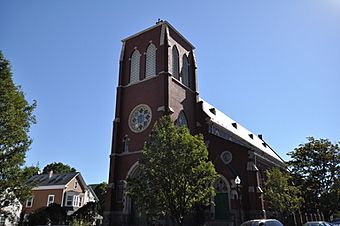
St. Patrick's Church
|
|
| Location | Dudley, Hampden, Dunmore & Magazine Sts., Blue Hill & Mt. Pleasant Ave., Roxbury, Boston, Massachusetts |
|---|---|
| Area | 1.7 acres (0.69 ha) |
| Built | 1872 |
| NRHP reference No. | 16000454 |
| Added to NRHP | July 18, 2016 |
The Governor Shirley Square Historic District is a special area in the Roxbury neighborhood of Boston, Massachusetts. It includes several important buildings like churches, homes, and businesses. These buildings are found where Dudley, Hampden, and Dunmore Streets meet.
This area is named after William Shirley, who was a colonial governor. It became a busy place in the 1870s and 1880s. This happened after Roxbury became part of Boston in 1868. The district was added to the National Register of Historic Places in 2016. This means it's a place worth protecting because of its history.
Contents
What Makes Governor Shirley Square Special?
Governor Shirley Square is shaped like an "X" where several streets cross. It's located southeast of Nubian Square, which is another important area in Roxbury. Six historic buildings stand around this intersection and along Dudley Street.
Buildings to See
All these buildings are made of stone or brick. They were built between 1872 and 1896.
- The most eye-catching building is the St. Patrick's Roman Catholic Church. It was built in 1873. It has a special design called Gothic Revival style, which looks like old European churches.
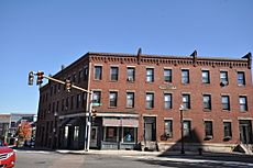
- On the west side of Dudley Street, you'll find two large apartment buildings. These were built in the 1890s. They have shops on the ground floor and homes above.
- The McDermott Block was built around 1880. It's a large building with five sections. It also has both homes and businesses inside.
- Further down Dudley Street, there are two important city buildings. One is the Roxbury District 9 police station, built in 1872. The other is a fire station from 1874.
A Look Back: How the Square Grew
Before the 1840s, the area around Governor Shirley Square was mostly farmland. It wasn't very developed.
From Farms to City Life
Development started nearby, in the Mount Pleasant area. This happened between the 1840s and 1860s. In 1860, a streetcar line was added. This line used horses to pull the cars. It ran down what is now Dudley Street. This helped the area grow and become more populated.
Roxbury Joins Boston
In 1868, the city of Boston officially took over Roxbury. This is called "annexation." After this, Boston started making big improvements near the square. They built the police station and the fire station. These buildings helped the community.
A Growing Community
The number of Catholic families in the area was also growing. This led to the building of St. Patrick's Church. The intersection was officially named Governor Shirley Square in 1913. It was named after William Shirley, who was a governor a long time ago. His old home, the Shirley's mansion, is a few blocks south of this square. It's also a very important historic landmark.


