
Bay of Isles facts for kids

The Bay of Isles is a large bay on the north coast of South Georgia. It's about 9 miles (14.5 km) wide and goes inland for about 3 miles (4.8 km). This bay is located between Cape Buller and Cape Wilson.
James Cook, a famous British explorer, discovered the Bay of Isles in 1775. He named it this way because he saw many islands inside the bay – at least twelve! This area is also very important for birds. Out of 31 types of birds that breed on South Georgia, 17 of them can be found right here in the Bay of Isles.
Contents
What Makes Up the Bay of Isles?
The Bay of Isles is very wide and has a coastline that is quite tricky. It includes many smaller bays, coves, and inlets. Many of the points and headlands (pieces of land sticking out into the sea) around the bay have their own names.
The West Side of the Bay
The western part of the Bay of Isles looks a bit like the letter "C". The northernmost tip is a rough piece of land called Cape Buller. Near it is Cleveland Rock. Above the cape, you can see Pyramid Peak. Just south of Cape Buller is Barlas Bank, which is a small underwater area.
At the top of the "C" shape, there's a cove called Koppervik. Breakwater Point is on the western edge of this cove. Further along the west coast, you'll find Sheathbill Bay. Next to it, separated by a small cove, is Rosita Harbour. Ram Head is a point that separates Rosita Harbour from Camp Bay, which is to the south.
After Camp Bay, Shag Point separates it from Sunset Fjord. Sunset Fjord makes up the entire southwest corner of the Bay of Isles. Inside Sunset Fjord, just south of Shag Point, is Jock Point. Two glaciers, Brunonia Glacier and Clayton Glacier, flow down Murphy Wall and into Sunset Fjord.
The South Side of the Bay
.jpg)
Markham Point is on the west side of Ample Bay. Ample Bay is about 2 nautical miles (3.7 km) east of Sunset Fjord, along the southern coast of the Bay of Isles. Right inside Markham Point is Paul Beach. This beach is made of small stones and is about 0.55 nautical miles (1 km) long. Higher up, it's covered in tough grass called tussock. Behind the beach are cliffs about 35 meters (115 ft) high.
East of Paul Beach, Grace Glacier flows into Ample Bay. This glacier marks the west side of Salisbury Plain. Lucas Glacier is on the east side of the plain.
Continuing east along the south coast, Luck Point forms the west side of Sea Leopard Fjord. This is a large fjord, about 1.15 nautical miles (2.1 km) wide. Bellingshausen Point is on its east side. Right next to it is Beckmann Fjord, with Daisy Point marking its easternmost side. Just outside Beckmann Fjord is Hecate Rock, an underwater rock that is only 4.2 meters (14 ft) deep at its shallowest point. Austin Glacier flows north into Beckmann Fjord. Finally, the farthest east side of the Bay of Isles is marked by Cape Wilson.
Islands in the Bay
The Bay of Isles is famous for its many islands. Many of them are named after the birds that live there:
- Albatross Island (named after the albatross)
- Crescent Island
- Invisible Island
- Mollyhawk Island (named after the mollyhawk)
- Skua Island (named after the skua)
- Petrel Island (named after the petrel)
- Prion Island (named after the prion)
- Tern Island (named after the tern)
How Features Got Their Names
Many different explorers and scientists have helped map and name the places around the Bay of Isles over the years.
Cape Buller was discovered and named in 1775 by James Cook. Markham Point was named on a map in 1912 by J. Innes Wilson.
Between 1912 and 1913, Robert Cushman Murphy explored South Georgia on his ship, the Daisy. He mapped and named several features. Beckmann Fjord was named for Captain Beckmann, who sadly died in a whaling accident in 1912. Bellingshausen Point was named after Admiral Thaddeus Bellingshausen. Murphy named Brunonia Glacier after his university, Brown University. Cape Wilson was named for American President Woodrow Wilson. Grace Glacier was named for Murphy's wife, Grace Barstow Murphy. He named Lucas Glacier for Frederic Augustus Lucas, who was the director of the American Museum of Natural History. Sunset Fjord got its name because Murphy could see the sunset perfectly behind it from where his ship was anchored.
Other places like Ample Bay, Barlas Bank, Camp Bay, Jock Point, and Luck Point were mapped and named by a group called Discovery Investigations (DI) between 1928 and 1930. Camp Bay was named because a temporary camp was set up on its southern shore. Jock Point was named after J. "Jock" Purvis, a member of the DI survey team.
The name Koppervik was likely used by Norwegian whalers before 1930. Names like Austin Glacier, Breakwater Point, Ram Head, and Shag Point first appeared on a British map in 1931.

The South Georgia Survey (SGS) explored the area from 1951 to 1957 and named several more features. The SGS named Rosita Harbour after their whaling ship, the Rosita. In 1952, the SGS approved the name Daisy Point, also named after the ship Daisy.
Two scientists from the Falklands Islands Dependencies Survey (FIDS) stayed at Paul Beach for research from 1953 to 1954. They named the beach after their buoy-boat, the Southern Paul.
Cleveland Rock was mapped by the SGS and named in the 1980s for Benjamin D. Cleveland, who was the captain of the ship Daisy. Clayton Glacier was named for Roger A.S. Clayton, a geologist. Sheathbill Bay was named for the snowy sheathbill birds that live there. Hecate Rock was named in 1984 after the ship HMS Hecate, which almost hit the rock during a survey in 1983.
Images for kids
-
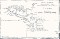
Pendleton's map lists it as the "Bay of Island"
-
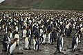
A colony of up to 60,000 King penguins (Aptenodytes patagonicus) on Salisbury Plain at Ample Bay.
-
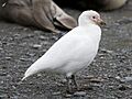
Snowy sheathbill, the bird that Sheathbill Bay is named after.
See also
In Spanish: Bahía de las Islas para niños
